The Western Shard at Federation Square was a compromise to the original design, but it was built largely stylistically integrated with the rest of the square, and is therefore integral to the whole.
I must apologise to the world for the lateness of this post, life moves so damn quickly these days. Tomorrow, Wednesday September 12 is the deadline for submissions to Heritage Victoria in opposition to the awful and unnecessary new Metro Station entrance proposed for Federation Square. I also apologise the layout on this post is a little haywire but I haven't got time to fix it right now.
I write today encouraging all Melburnians to lift up their pens for what will not be the first time in defence of one of the world's premiere civic spaces, and will briefly run through the core arguments that we feel should inform the public objections.
The core of our objection to the proposal is that the Western Shard is specifically listed as significant in the site's interim heritage listing as adopted by Heritage Victoria. That means it is protected from demolition unless in the most exceptional of circumstances that demonstrate an overwhelming imperative to demolish the structure.
Quite simply, no such imperative is demonstrated in the plans submitted by the Metro Tunnel Project, and therefore the plans must be rejected.
The plans do not demonstrate any need to demolish the structure, because they do not give any valid reason why a station entrance could not be constructed within the existing structure.
A Disingenuous Proposal
disingenuous - adjective. Not candid or sincere, typically by pretending that one knows less about something than one really does.
It's one of my favourite words - disingenuous. Once you've conceptually grasped it, you start to see it in evidence everywhere if you spend any time at all engaged with public policy. Politicians, of course, are severely recidivist criminals here, but most public servants (especially those with public facing roles) are well trained, both formally and informally in the dark arts of the disingenuous.
So, what IS the imperative to demolish this structure and erect a low-rise, lightweight, see-through structure in it's place? It is VERY obvious that this has been done for Apple (scum), probably at their insistence, because the existing structure, as clearly shown in the photo below, would block sightlines to the Apple (scum) store from the existing retail strip, and indeed from the entrance to the Square itself.
Image from the submitted plans clearly showing the shard obscures the location of the proposed Apple (scum) store from the existing retail strip.
The entire proposal is therefore both disingenuous and in bad faith to both the public at large, who are being sold a lie concerning the reasons why this project is deemed necessary, and to the processes of Heritage Victoria, which are being gamed.
Precedent Shows This Must Be Rejected
The clear precedent for Heritage Victoria decisions is that arguments of mere economic convenience to the applicant or one of the applicant's stakeholders should not be accepted as the basis for demolition of a protected structure. Without any pressing argument to this effect contained in the proposal's business case, Heritage Victoria must reject the proposal. The heritage citation for the site, as adopted in interim by Heritage Victoria clearly states: "The Western Shard The Swanston/Flinders Street corner of the site is occupied by the Western Shard, a glass-walled pavilion which provides access to the underground Melbourne Visitor Centre. The entrance features interactive news tickers in colour LEDs and small screens promoting current activities." The proposal posits that "as it is not an element that reflects the original design intent, we consider that the proposed demolition
and replacement with another sympathetic structure is acceptable." We find this an appalling statement from a heritage professional. Where the feature in question is specifically cited as significant, trying to second guess that citation after the event and now argue the feature is not significant does not represent a valid argument.
Attempting to Alter a Protected Heritage Place
Furthermore the proposal itself concedes that the proposed structure is also not stylistically consistent with the original design intent for Federation Square (a position that is completely undermined by the previous argument), stating that "architecturally, the proposed eastern station entry for the Town Hall Station draws on the same ‘NewModern’
functionalist architectural tradition of Federation Square without attempting to replicate the
Deconstructivist architectural forms of the Lab/Bates Smart design."
Coupled with the proposed introduction of yet another new design style in the form of Apple (scum) store, we can clearly see how through the complete raft of changes proposed for the space, that their effect would be to take a coherently-designed world-beating, deeply symbolic, major architectural space of tremendous significance to most Melburnians, which even in its short lifespan is already iconic to the city, and replace two of the existing buildings replaced with new structures in TWO COMPLETELY NON-COHERING STYLES, and thereby literally ruin the entire whole, as we explained in an earlier post.
How Can I Help?
So, we urge all caring Melburnians to urgently get tapping on their keyboards and make these points politely and succinctly to Heritage Victoria by close of business, Wednesday September 12.
I'd like to return specifically to some of Alan's concerns in the concluding blog to this series. But first, let's take a look at the project as it is currently proposed, and make an assessment of the logical "next steps" in project planning to ensure we return maximal benefits from the project for all Victorians.
In part one here today, we'll look at the majority of the network, and the portion most likely to be delivered as tunnel - from the Frankston line through to Craigieburn.
Next week, we'll look at the remainder of the network through the western suburbs and how the delivery and timetabling options and imperatives out there actually look very distinct to the underground portion of the network.
In part three we'll look at some rudimentary cost-benefits and respond to some of the common critiques of the plan as well as look at some further incremental developments to consider to address any major goals this orbital rail plan is unable to, and so deliver a maximum benefit metro style heavy rail system for Melbourne.
i'M SORely what Melbourne needs
For starters, we need to do something about an acronym. The notional Wombat project suffered a little from nomenclature overload, usually going by some variant of "Urban Orbital Rail" and "Suburban Rail Loop". Other commentators seem to have just settled for the obvious - the government document is entitled "Suburban Rail Loop Strategic Assessment", so SRL it is.
I'm probably a little bit tragic in this regard, but I look at that acronym and the only words that enter my dyslexic head are "Stevie Ray Vaughan". So I think we can and should do better. A loop is necessarily orbital, so we can turf one of those two words, and I think it needs a bit more LOCAL, yokels. So I'm going with Melbourne Suburban Orbital Rail or MSOR, and you'll just need to adjust your sets accordingly.
Orbital Rail Benefits - Recapped
It's all about the network effect. Human civilisation's greatest quantum advances have all taken place as a result of technology that enhanced our ability to network together as human beings. The invention of railroad itself is but one critical illustration of the phenomenon.
Melbourne Employment Densities and Centres with Tram/rail Networks
The main benefit of the policy - the entire point of spending $50bn is to purchase the necessary enabling infrastructure to allow us to build the ever more mythologised "20 minute city". The point of this MUST be a radical re-envisaging of the MAJORITY of suburban employment journeys to enable a significant mode shift to public transport.
But we also simultaneously discussed the ways in which Sydney has done a far better job of the planning side of the equation - on facilitating remedial land uses and attracting employers into rail-enabled locations.
The real beauty of orbital rail as imposed on the existing radial network is that it creates innumerable opportunities for multiple heavy rail "spokes" to operate radially IN to the new suburban employment centres, over-writing Melbourne's current hugely dispersed suburban employment patterns with a new map that creates a critical mass of employment destinations walkable to heavy rail stations.
And where the heavy rail network previously left enormous public transport blackspots across Melbourne's eastern suburbs, the networked, web-like lattice into which it is transformed by MSOR means that vast swathes of the east in any given direction are now just a few train stations from the new employment centres, whereas previously a commuter in Box Hill would have needed to travel in to Richmond and then out again to get to Glen Waverley, around tripling the necessary travel distance versus car.
That this is not a high demand journey today is not the point, the above shows exactly why the demand isn't there.
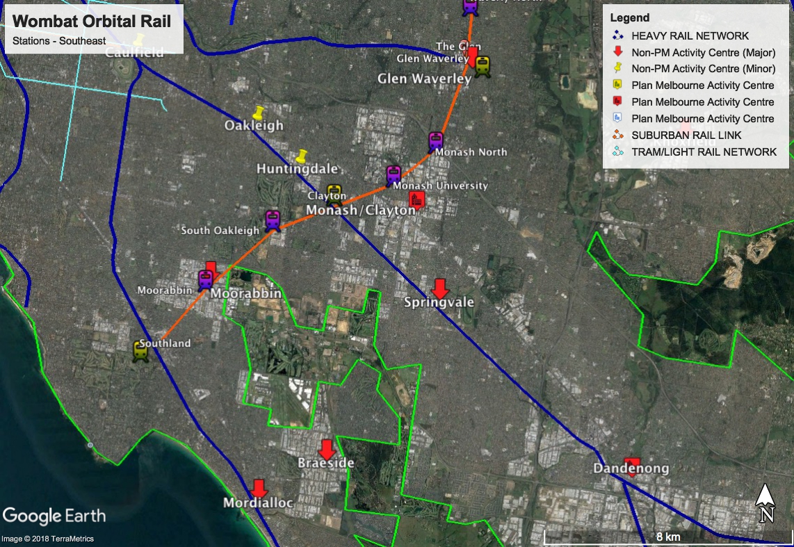
Wombat's Melbourne Suburban Orbital Rail Route - Southeast (orange)
We're planning here for Melbourne 2118, from which vantage point, this project will be deemed to have paid for itself several times over. In the same way we'd decry the insanity of ripping up any of our established lines today (and again, the Upfield line would never have stood up to Infrastructure Victoria's methodology if proposed today, as they would assume it would cannibalise 60% of its ridership from the Craigieburn line).
Not Because It's Easy, Because It's Hard
It's very important that we convey that it is NOT POSSIBLE to do the cost-benefit calculations on MSOR, without first calculating the potential benefits for re-shaping land use, employment and transportation patterns all along the corridor. And you CANNOT do that calculation without doing ALL the detailed planning on exactly where the stations are going, how much viable land exists around the new station for consolidation into an urban activity centre, what the potential of that location is as an employment destination, and so on.
In short, the potential of MSOR is less as a pure transportation project and more as a tool to guide land use and strategic planning. Because if history teaches us humans anything - we have two great assets as a species which have enabled all the marvels of our civilisation down the ages. One of those is our ability to network together with our fellow human beings. The other is an ability to plan collectively and work strategically towards a long term goal.
We've only got to where we are as a species by incrementally envisaging better worlds in exactly this fashion. MSOR is a project that dials in a very specific vision of a better world and then goes about planning for it.
Thus is Melbourne Suburban Orbital Rail the very acme of visionary, big picture human undertakings such that truly elevate one's eyes to the horizon, that actually do make a body ever so slightly proud to be a tiny chapter in humanity's infinite history.
Optimising the Route
The initial Strategic Assessment provided by Development Victoria leaves largely open the question of how many new stations will be included in the project, instead nominating a number of broad locations that are intended to be served, as well as indicating the likely interface stations with the existing network.
So, let's look at the Wombat-optimal suggested solutions to some of the core issues. Let's map out an actual proposed network, starting in the Southeast.
Our considerations here are really threefold - to cater to established employment centres currently poorly served by public transport - to facilitate enough new employment centres in order to render the 20 minute city concept feasible - and to provide new commuter stations in existing rail black spots.
We strongly suggest that enabling legislation should be considered for this project which grants full control to the Planning Minister for any planning issues within specified distances around the station sites - with their scope/size roughly scaled according to the 'site potential' ratings suggested below. We'd suggest doing the same for ALL the station sites in yellow and red in the map above.
We would then suggest either a new standalone body, or something within Places or Development Victoria which is responsible for involving stakeholders and developing masterplans for each of the zones, which may or may not have some responsibility for actual land acquisition or consolidation of sites as necessary. It would ideally have a charter to ensure that sensitive or heritage neighbourhoods were preserved, and that larger scale or higher intensity development were focused away from residential areas, but the body's charter would essentially be to develop these areas as employment zones.
Where the government has already nominated value capture as a key potential funding source for the project, we'd suggest you've already taken several large steps towards the need for just such a body or bodies to be established anyway.
Finally, we'd LOVE to see some sort of incentive scheme for large employers currently located a long way from public transport be facilitated to relocate to these new activity centres, and the owners of those large industrial sites be given incentives to redevelop those as residential or other beneficial re-uses.
Which Way South?
Regular readers will recall that the Wombat Plan last left this concept with two feasible N-S routes through the eastern suburbs - an inner AND an outer connection and actually advocated the staggered construction of both. The inner route is largely the one as put forward by Development Victoria. The outer route ran via Doncaster to Ringwood then on to Knoxfield, Dandenong, Braeside and Mordialloc.
The outer route was mostly about enabling rail to those several existing centres, which it should be more than a footnote here, are still probably crying out for some form of enhanced public transport solution on the basis that it's much harder to start an entire new employment centre than to better plan for an existing one.
I'm a little heretical amongst transport buffs, in that I view "park and ride" models for heavy rail into suburbia as a very major success factor in improving the overall mode share for public transport in Melbourne, and accordingly the park and ride potential of the various sites is something we'll be considering in some detail.
I should apply my usual caveat in that the first-best option is obviously having suburban bus or even new light rail services operating super-frequently in to the station from local destinations as feeders to the heavy rail system rather than cars. The extent to which further such enabling policy were put in place would actually have a serious impact on the size of the potential benefits column for MSOR, and so obviously the issue warrants addressing.
But one of the issues this project contends with is that it is retrofitting a european style heavy rail metro into areas with significantly lower population densities than much of Europe, and in order to plan realistically for final yards travel in a city that has never had a good relationship with its suburban bus network, we simply need to factor cars in for the foreseeable future.
Optimising the Station Locations
Urban Melbourne recently carried some good commentary showing what the development pipeline looks like in the suburbs slated to receive MSOR. It can be quite illuminating to read alongside my proposed route. When you get a sense of the quantum of change that is already happening, the benefits of this project appear to be as much in being able to actually take direction of that change as they are in facilitating anything new.
SOUTHLAND STATION - FRANKSTON LINE JUNCTION
Site potential: A
Park and Ride Potential: B
The first question arises at the bottom of the 'clockface'. The Strategic Assessment resolutely states that the route is intended to meet the Frankston line at Cheltenham. This has, however, widely been interpreted as actually meaning "Southland" station, and we would very much encourage the latter.
One need only look at the land usage around the shopping centre, even before thinking about further possible apartment towers on top of the shops to know which site has the greater redevelopment potential as an employment/activity/residential centre. We embark at Southland.
Unlocking the park and ride potential of the site, given it is surrounded by residential areas would be a key success factor, and this would obviously be dependent on arriving at a mutually beneficial arrangement with Westfield to utilise the existing parking areas.
MOORABBIN STATION
Site potential: B
Possible Location: Blamey and Nelson Rds
Park and Ride Potential: D
Moorabbin represents one of the few properly established existing employment centres that we are adding to the heavy rail network, so the proposed location is really at the heart of the industrial zone.
We would suggest significant scope exists, given the large nature of the landholdings in the area to create a small central retail/hospitality zone around the station, but this would not be an attractive location for residential redevelopment at scale. Moorabbin's role would remain primarily as an industrial-style employment zone, and as such park and ride is a lower priority at this location.
SOUTH OAKLEIGH STATION
Site potential: C
Possible Location: Huntingdale and Centre Rds
Park and Ride Potential: B
South Oakleigh is currently a small scale employment zone, which has appreciable redevelopment potential for potentially some more intensive scale office and retail developments around the new station. It is also bounded by significant residential areas, so we would suggest some property acquisition to enable construction of a park and ride structure would be a key success factor.
CLAYTON STATION - DANDENONG CORRIDOR JUNCTION
Site potential: B
Park and Ride Potential: C
This station has always been at the fringe of the actual employment zone, so its catchment contains a mixture of residential and commercial sites with some consolidation potential as the broader employment zone develops.
MONASH UNIVERSITY STATION
Site potential: D
Possible Location: Around the site of the current bus terminus at the Southern end of the campus
Park and Ride Potential: N/A
The core reason why this station has scored so low on the site potential rating, is that locating the station well for on-campus purposes renders its potential to cater to surrounding residential and employment areas minimal, and because we can't be stopping the trains every 500 meters, forces us to place the second new Monash precinct station in a sub-optimal location for unlocking the maximum potential value of the precinct.
The potential to reduce car dependency amongst the campus' 30,000 odd students and academics is significant enough that these issues are obviously unavoidable, and accordingly park and ride would be inappropriate and unworkable here.
MONASH NORTH STATION
Site potential: A
Possible Location: Dunlop and Springvale Rds
Park and Ride Potential: B
Again, this is probably not the optimal location from a broader precinct planning perspective - so if forced into a site like this, the precinct planning should obviously do what it can to try and develop something of a walkable town centre in the vicinity the station.
GLEN WAVERLEY STATION - JUNCTION
Site potential: B
Park and Ride Potential: C
An established site obviously, does a reasonable job catering to the adjacent Glen shoppping centre, and has a reasonably good residential catchment with a small number of commercial sites nearby providing some redevelopment opportunity.
WAVERLEY NORTH STATION
Site potential: D
Possible Location: Springvale Rd
Park and Ride Potential: B
An entirely residential area, this station would be a purely commuter station, and therefore sufficient landholdings to enable appreciable park and ride would need to be considered.
BURWOOD EAST STATION - #75 TRAM INTERCHANGE
Site potential: B
Possible Location: Burwood Hwy and Springvale Rd
Park and Ride Potential: B
A great opportunity to develop a more pedestrian-friendly mixed use zone around this intersection, where the 75 tram also forms another two "spokes" into a possible employment hub, and where the size of the land holdings thereabouts offer decent scope for renewal, we would urge strong consideration be given to giving this potential employment hub much more focus than it might appear to warrant at first glance.
BLACKBURN STATION
Site potential: D
Possible Location: Blackburn Rd
Park and Ride Potential: B
An entirely residential area, this station would be a purely commuter station, and therefore sufficient landholdings to enable appreciable park and ride would need to be considered.
MIDDLEBOROUGH STATION
Site potential: C
Possible Location: Middleborough Rd
Park and Ride Potential: B
Another site with some established commercial/industrial and good potential for an actively planned mixed use precinct.
BOX HILL STATION - LILYDALE/BELGRAVE JUNCTION - #109 TRAM INTERCHANGE
Site potential: A
Park and Ride Potential: B
Box Hill station, as poorly integrated as it is with the existing shopping centre and bus/tram interchanges, presents a real opportunity, if the long mooted complete re-build of the thing were still on the cards, then Box Hill unquestionably has the greatest potential of any eastern suburbs site on the MSOR for an effective high density residential, office and retail hub.
However, the issues relating to transport connectivity would need some really good planning around them to maximise the opportunity here. We should also seriously consider the extension of the 109 tram along Whitehorse road to provide a new rail "spoke" into this highly significant potential activity centre.
SPRINGFIELD STATION
Site potential: D
Possible Location: Springfield and Dorking Rds
Park and Ride Potential: B
An entirely residential area, this station would be a purely commuter station, and therefore sufficient landholdings to enable appreciable park and ride would need to be considered.
Specifically situated to titillate Simpsons fans.
DONCASTER STATION
Site potential: A
Possible Location: Shoppingtown
Park and Ride Potential: A
Another established shopping centre and major bus terminus with significant surrounding residential, including some medium-high density as well as commercial and industrial. Excellent potential for effective creation of a medium-high density mixed use zone, which would posit interesting challenges in needing to make an effectively private space (the shopping centre) the town centre.
WEST DONCASTER STATION
Site potential: C
Possible Location: Doncaster Rd & Eastern Fwy
Park and Ride Potential: B
Some small scale nearby retail, but a mostly residential area, and thus this would primarily be a commuter station.
BALWYN NORTH STATION
Site potential: D
Possible Location: Bulleen Rd & Eastern Fwy
Park and Ride Potential: B
An entirely residential area, this station would be a purely commuter station, and therefore sufficient landholdings to enable appreciable park and ride would need to be considered.
HEIDELBERG STATION - HURSTBRIDGE JUNCTION
Site potential: C
Park and Ride Potential: C
As an established station servicing a sizeable mixed use retail, commercial and medical precinct, it offers limited scope for additional park and ride, nor would we really want to encourage that near an established retail shopping strip.
HEIDELBERG HEIGHTS STATION
Site potential: C
Possible Location: Edwin and Bell Sts
Park and Ride Potential: B
Largely residential area, some small scope for enhanced commercial along the main roads in the vicinity.
NORTHLAND STATION
Site potential: B
Possible Location: Northland S/C
Park and Ride Potential: C
Largely established industrial area, but as industrial does offer reasonable scope for future precinct planning. A core challenge here again would be to effective activate anything beyond the shopping centre - perhaps the best realistic outcome would be a mixed use development of the existing shopping centre.
WEST PRESTON STATION
Site potential: C
Possible Location: Waterdale Rd
Park and Ride Potential: C
This is an existing small scale industrial area south of La Trobe University, and as such offers tremendous opportunity for creating a transport-oriented employment precinct either allied or independent to the University
LA TROBE UNIVERSITY STATION
Site potential: C
Possible Location: Somewhere near the Agora
Park and Ride Potential: N/A
The issues here are similar to Monash, except the larger distances mean that station location doesn't really force compromises elsewhere, although it won't be a long way between stops to Plenty Rd ...
BUNDOORA PARK STATION - #86 TRAM INTERCHANGE
Site potential: C
Possible Location: Plenty Rd
Park and Ride Potential: B
Some larger dispersed commercial and industrial sites along Plenty Rd. The large amount of surrounding parkland makes this a less than ideal point for the actual interchange with the tram, and so we suggest positioning the station to attempt to garner the largest residential catchment for the station.
THOMASTOWN SOUTH STATION
Site potential: B
Possible Location: Cheddar Rd & Hanrahan St
Park and Ride Potential: B
Thomastown is a kind of sprawling, lumbering semi-industrial suburb that was absolutely gutted by the 1990s recession - having been home to enormous swathes of now vanished manufacturing. The area is only really just now starting to re-make itself, and it has enormous potential for re-development of almost unlimited scope, scale or use.
THOMASTOWN STATION - MERNDA JUNCTION
Site potential: B
Park and Ride Potential: B
Surrounded by variously industrial, retail and residential zones, Thomastown Station offers significant potential for the creation of an effective mixed use neighbourhood, and in fact if we were grading the prospects of the activity centres, we think no other such centre presents so high a potential with the addition of orbital rail. As we can see, it's possible to create fully 3 stations (2 new) which are very well located to create a large scale, medium density mixed use suburb. We strongly suggest Thomastown needs to rise up the activity centre priority list accordingly.
THOMASTOWN WEST STATION
Site potential: C
Possible Location: Ring Road and Mahoney's Rd
Park and Ride Potential: B
Although this station would have a large residential catchment, it would also serve the eastern end of the larger industrial sites situated between Mahoney's and the ring road, providing some further redevelopment opportunities across the wider Thomastown activity centre.
CAMPBELLFIELD STATION - UPFIELD JUNCTION
Site potential: B
Possible Location: Camp Rd
Park and Ride Potential: B
Significant planning has already gone in to re-instating the former Campbellfield Station, which closed in 1956. In fact provision was made for the station during the recent level crossing removal, and this is an obvious urgency. It's long been an incredible frustration for users of the orbital smart bus routes that because of this station's absence they don't actually connect conveniently anywhere with the Upfield line. There are significant industrial, commercial and retail sites in the vicinity of the proposed station, including Campbellfield Plaza, such that the potential for developing an effective mixed use neighbourhood around the station is quite high here.
BROADMEADOWS STATION - CRAIGIEBURN JUNCTION
Site potential: A
Park and Ride Potential: A
Broadmeadows is obviously one of the main designated activity/employment centres under Plan Melbourne, around which extensive work on future land use planning and so on is already underway. We will look next week at the possible infrastructure issues around the station, where it is anticipated this would be the point that we finally rise above ground since we first hopped on at Southland, from this point, we need to share some infrastructure with the existing network, so we'll discuss that next week.
Profiling the New Stations
We could break all these down by typologies relatively easily and these would determine what type/how much enabling policy you put around facilitating new uses for each, looking something like the following. If we throw in a few of the western suburbs stations to complete the picture, we're looking at something like the following:
2. Existing or Potential New Employment Centres
Thomastown
Campbellfield
Burwood East
Middleborough
Moorabbin
South Oakleigh
Glen Waverley
Northland/Heidelberg West
Sunshine North
Keilor Park 3. Universities
Monash
La Trobe 4. Shopping Centres
Doncaster
Southland
The Glen/Glen Waverley
Airport West
Northland
(THINK about it - you will be able to shop 5 massive malls in 1 day with 1 Myki (or 2050 equivalent)) 5. Residential/Commuter
Waverley Nth
Blackburn
Springfield
West Doncaster
Balwyn Nth
Heidelberg Heights
Bundoora Park
Keilor East
So that gives us around 20 "destination" stations, and we contend that this is number is much closer to the optimal number of activity centres than the last version of Plan Melbourne posited, if we are to enable a "20 minute city" in more than rhetoric. We contend that facilitating these new land uses and transportation patterns in to them is a goal so important that it is worth spending $50bn over an extended timeframe to solve. But more on that in part three.
Be sure to tune in next week, and we'll look at the western portion of all this in a lot more detail, as well as consider what a Melbourne rail timetable might look like in 2050, once all of this is up and running.
As usual questions, comments and critique are welcome - we love hearing your feedback!
Melbourne appears to be inching ever closer to proceeding with an Airport Rail Link, with the Federal Government promising to contribute $5bn towards the project, in spite of the ample evidence that $5bn would be far better spent on the Melbourne rail network by extending it to Rowville, Monash or even finally electrifying the Melton line.
Major credit to the State Government for their response to Turnbull's pure populism play. I've long had a sense that Daniel Andrews knows full well how poorly airport rail stands up to a proper cost-benefit analysis relative to almost any other possible similarly scaled improvement to Melbourne's rail network.
The state government has been insistent that if this project proceeds, it needs to be about more than just getting businesspeople to their flight on time on the dozen or so times a year the majority of them will ever travel.
Sunshine Station in Melbourne's west has enormous potential to develop as a new transport
and employment hub for the entire western region.
Unlocking The True Potential of Melbourne's Airport Rail Link
We've discussed this as nauseum here in the wombat burrow and so I won't bore you further tonight, particularly as the debating horse appears to have bolted somewhat. Some form of airport rail link is going to happen, and so as we've equally insisted before, we are about making sure if it goes ahead that it delivers the maximum benefit to the Melburnians who matter most - those who presently have tenuous access to viable public transport options. Doing it for Zone Two, as we like to say.
The state government is correct to situate the real scope of this project's potential in the context of "unlocking the City's west", and of seeking to ensure, as Melbourne's growth rebalances west now that little opportunities to expand east remain, that we don't repeat the mistakes our planners made over the part 50 years in creating vast greenfields development zones situated in public transport black holes, thereby locking their residents perpetually into inequitable, antisocial and unhealthy transport options largely confined to car dependency.
The Regional Rail Link project remains little understood and unheralded by most Melburnians, but I maintain it is the single most important infrastructure project that a Victorian government has undertaken in my lifetime. It is unquestionably John Brumby's greatest legacy. In years to come Melbourne will realise that this project has nothing to do with V/Line, because it's eventually going to be incorporated into the metro rail system, and it creates the opportunity to plan vast new greenfields residential sites around heavy rail.
As one also suspects that sticking to the original, more ambitious Metro rail project while canning the East-West Link will come to be seen as Daniel Andrews' eternal gift to Melbourne. In time I hope this decision will come to be seen as the first significant move by any Victorian politician to effect a recalibration towards mass transit investment which in turn set Melbourne up to become one of the great, if not the eminent industrial and social fulcrums of the Asia-pacific region.
The government also deserves credit for placing the project in the context of the possibilities to enable fast rail to Geelong. So we're seeing something of project's aims being lifted towards the horizon in two key dimensions - better enabling a public transport-oriented future for the West, and advancing the decentralisation agenda by rendering Geelong a viable commuter city to Melbourne.
I intend today to dwell today mostly in the former dimension as to a large extent the big questions around fast rail are all technical-boring ones regarding how to do it. My main agendas are seeing the line divert via Avalon, and at what point are we going to electrify the regional rail link anyway?
And I have two broad based pleas for the government to insist upon being part of the project if we are to have at least the benefits column of Turnbull's vanity project maximised.
1. Let's Electrify the ENTIRE Albion Rail Corridor Through to Jacana/Craigieburn
The below illustration shows the state government's approximate preferred route for airport rail as the leftmost orange track. Green is the Urban Growth Boundary, light blue is the existing tram network and dark blue heavy rail.
My proposal is to also electrify the entire remainder of the Albion freight corridor to where it reconnects with the Craigieburn line at Jacana (the right hand orange spur).
The point of this is to allow for services running Broadmeadows-Footscray (or potentially further), leaving the airport link free to run express past all but two of my new commuter stations I'm suggesting below. We've then plugged one of the largest heavy rail blackspots in Melbourne, created viable local heavy rail transit options into several existing and potential employment centres, and furthered the goal of de-radialising the network.
Furthermore the entire northwest has indirect heavy rail access to the airport. And this is as much about acknowledging that the airport is actually one of the few existing concentrated employment zones outside Melbourne's CBD as it is travellers.
Their journey would necessitate one change at the new Keilor Park station (more below) to connect with the airport rail link proper, but Melbourne folk are only unused to interchange travel because of the existing radial nature of the network.
The point of this full electrification is really about giving people in the northwest a viable heavy rail transport option to local employment centres, while also facilitating the growth of those centres.
2. Let's Build FIVE New Commuter Stations
I can already hear the armchair experts slingshotting out of their recliners. "Don't be a fool, you know every new station adds a huge amount of time to the journey, and we need to be competitive with road."
Well, bulldust. The main benefit of airport rail to commuters is RELIABILITY. So long as we can tell people exactly what time they will be at the Tullamarine terminus, they will plan their journey accordingly. They will not do a mental calculation on exactly how long a hypothetical road journey might take.
Regardless, as per above, we will only catering to two of the new stations on the actual airport rail link.
So, my proposed airport rail would have stops at the CBD obviously and travel via the Metro Tunnel to stop Footscray, Sunshine then three new stations - Keilor Park, Airport West and Tullamarine Airport, which would provide for a reliable service that is time-competitive with road and which delivers maximal integration with the existing commuter network.
The picture is completed with new stations at Sunshine North, Keilor East and Gowanbrae, all servicing either existing employment centres or greenfields residential, approximately in the locations set out below.
Future Proofing the West
You will also note the above diagrams include the sometimes mooted extension of the 59 tram line to the airport. It's really an afterthought, but I was interested in seeing what the airport's potential public transport catchment looked like with that added. I think it's fair to say this would not be used by travellers, this is purely to create a maximally public transport enabled employment centre whose effective catchment would now reach all the way down to Essendon.
I intend to spend more time breaking down some of the more recent journey to work data to gain some idea what percentage of Tullamarine airport and related facility employees, live within this catchment, and ideally that data would inform the decision of whether the tram connection was worthwhile.
And to ice this cake properly, if we scale back a little and look at a similar treatment for the inevitable Upfield Line extension (which already exists as unelectrified single track, shown in red below), and further back still to incorporate the Regional Rail Link (royal blue), with its potential for well planned and managed greenfields public transport oriented development, then the risen creation looks something like the image below.
Now, that starts to look more like my definition of a NETWORK - a decentralised lattice of interconnected nodes. And if we accept the other great wombat thesis that a radically decentralised rail network is necessary to secure Melbourne's future, the city's west suddenly looks full of potential for building great, sustainable communities with easy rail access to decentralised job centres.
Transforming Melbourne at Scale
And if we were to scale back even further, and if readers will allow me to bleat once more about the transformative potential for Melbourne of one or more outer suburban orbital tunnel/s (see HERE for the detail of THAT complete scheme), then ultimately I would suggest this entire project be considered but stage one in a much grander scheme linking all the major current and potential northern suburbs employment locations with heavy rail that operates radially IN to them as destinations in their own right.
Now, that to me looks properly transformative. And we are at the point where we need change on that scale for the sake of Melbourne's future. The current process of incrementalism is really just locking in the car culture by fiddling with small capacity improvements for rail while roads soak up the majority of the available resources. But one of those resources - space - is very finite, and we are surely approaching the point where we are physically unable to cater to much more incrementalism.
Let's make Turnbull's airport rail boondoggle the beginnings of Melbourne's quantum leap into a 20 minute city that actually exists outside the usual rhetoric.
Cost-Benefit Analysis really is a rubbish way of delivering public transport. I say this in particular reference to Infrastructure Victoria's debatable means of telling us Doncaster Rail was a dud, but a possible future Metro Two tunnel whose longest inner north component would in practical terms do little more than grant hipsters in the inner north subway stations, may well stack up.
Close the Upfield Line
The Upfield line would not pass a cost benefit analysis if proposed today - it would be projected to exclusively cannibalise existing Craigieburn line traffic. Yet we are today actually planning for the line as a crucial conduit to new northern growth suburbs.
But none of the cost of the tens of thousands of cars that would be thrown onto the choked roads network if we closed the Upfield line today would be on that original cost-benefit study.
And none of the benefits of having two rail lines rather than one serving entire new growth regions for decades to come would be in there either. And all of the usage projections for the new well serviced commuter stations in the outer west have exceeded original projections.
The point in bold here, is the benefits of having heavy rail covering your entire urban geography have been obvious with hindsight. Society today considers ALL the prior money here well spent, no smart politician has talked about closing about closing a train line in this city for 30 years.
The point is that if you are going to talk about benefits in such an economically rigid way that you hive off MOST of what society at large infers by the term, then you're deliberately and systemically building a world that is less responsive to society's values. Your entire methodology is actually invalid, not any scientific basis, but on a moral one. And because of this, your science is incapable of responding the problem.
Cost-benefit analysis is a discipline built on the same foundational faultline that undermines the entire discipline of economics. Statistical modelling is central to most of its foundational and core theories. This requires that an approximation model of the real world be created, and to do this, all manner of "assumptions" are made about the normal operation and behaviour of our world, and us the actors in it.
And here begins the problem, because the essential purpose of these assumptions is to allow for what is largely chaotic and random behaviour to be expressed in some form of mathematical expression.
Close the Frankston Line
To model Doncaster Rail, Infrastructure Victoria have made the assumption that fully 98% of its users would be cannibalised from the existing public transport system. You read that right. 98%. Without, apparently having anything obvious that might contextually support this figure, such as survey data from commuters in Doncaster (call me crazy). This number just appears from the air, and it's essentially this number that hobbles the entire cost-benefit study.
So, I have an unsolicited proposal for Infrastructure Victoria. Let's close the ENTIRE Frankston Line. Today. It doesn't stand up to cost benefit, because 98% of commuters would simply use other public transport modes. OK? THIS IS INSANE, Y/N????
But the other point is the only actual benefit by which Doncaster rail was assessed by Infrastructure Victoria was as a conduit to further enable access to the CBD employment zone, which is correctly assessed as a low priority.
But we will ask the question shortly, what if the real possibilities of Doncaster rail are being deliberately missed? What if rather than connecting Doncaster radially to the CBD, we explored options to connect it ORBITALLY to the heavy rail network? The needs this is then addressing are around creating suburban employment clusters and are instantly much more pressing.
You don't need to dig terribly deeply around the media at present to find articles talking of the increasing creation of TWO Melbournes - an inner city one that has excellent access to all the best paying jobs and which has viable public transport options and a suburban one which faces extensive and increasing daily commutes which are necessarily longer, car based and mostly to suburban destinations.
I believe Infrastructure Victoria has built a number of assumptions about this second Melbourne that are actually deeply classist and that literally dial in more of the same. Working people ('bogans') just love their cars, and this is an ideology of theirs.
Whereas I would start with, "we've never provided adequate public transport to the places where these people live, and so they don't use it, and if this isn't the most obvious causal factor here then there really must be something wrong with me."
And there's an increasing body of evidence that says there's apparently nothing wrong with me at all, and the other viewpoint is in fact dangerous.
Charting Transport in a Non-Parallel Universe
The latest, which has prompted this rant, is from the fabulous people at the Charting Transport blog. Certainly the most thorough publicly available data on journey to work in Melbourne is to be found there for anyone interested. I'll take up the rest of this post by referencing what I thought relevant and really shouting out what I think the lessons here are.
The report is about journey to work, so the data divides fairly neatly into data relating to ORIGIN and that relating to DESTINATION. On the origin side of things, one thing hits us square in the face.
Over the past 15 years, Public Transport mode share in Melbourne has increased ONLY in areas of the city with direct access to rail (tram, light or heavy).
The data shows it is only suburban household very proximate to the stations who will use the network in volume, further underlining the apparent weakness of the existing suburban bus network as a systemic support to rail.
And all this with quite a bit invested in the system in recent times, so the data is clearly telling us that simply continuing to invest incrementally in the system the way we have been will only reap the sort of incremental rewards we've seen here, not the significant change that everyone agrees is needed.
Footscray, Flemington, Docklands, Carlton, and South Yarra were more obviously on this list, but the report showed "public transport mode shares of over 50% can be found in pockets of West Footscray, Glenroy, Ormond – Glen Huntly, Murrumbeena."
Glenroy is uniquely well served by both the Upfield and Craigieburn lines. The last three are essentially the same region where the Frankston line diverges from Pakenham-Cranbourne, so this is theoretically one of the best served rail regions in Melbourne. Build it and they will come.
And we HAVE shifted the paradigm for new greenfields development in Melbourne's West with Regional Rail Link.
Charting Transport continue, "the biggest shifts to public transport in the middle and outer suburbs were in Wyndham Vale, Tarneit, South Morang, Lynbrook/Lyndhurst, Point Cook South, Williams Landing, Rockbank, and Glenroy. That’s almost a roll call of all the new train stations opened between 2011 and 2016."
I think we should all be crowing about this more, including the advocates for working Melburnians. This is not remotely how we built Noble Park. We seem to be laying the foundations of MUCH better planned communities for tomorrow's 'second Melburnians', and the communities themselves are voting with their feet. Build it and they will come.
I think it's extremely important that we are looking right now at making sure ALL the modifications to Upfield/Craigieburn needed to serve the growth communities in the north are as strategically well forward planned as Regional Rail Link was, and probably gotten underway today in preference to tomorrow. Having built it BEFORE they got there (hello, Caroline Springs station) seems to have been a success factor here.
Or Don't Build it, and They Won't Come
Unlike Sydney (and we've discussed this before), almost nobody is travelling to suburban work destinations in Melbourne by public transport, however the report clearly shows that concentrating jobs in suburban locations properly serviced by heavy rail is a key success factor in reducing car dependence for journey to work.
"There are some isolated pockets of relatively high public transport mode share for journey to work in the suburbs, including
34% in a pocket of Caulfield – North (right next to Caulfield Station),
33% in a pocket of Footscray (includes the site of the new State Trustees office tower near the station),
25% in a pocket of Box Hill near the station, and
17% at the Monash University Clayton campus
an area near Camberwell station (26.8% PT mode share)
Swinburne University Hawthorn (39.8% PT mode share),
a zone including the Coles head office in Tooronga (11.2% PT mode share)"
The commonality here is all too obvious. All are very near heavy rail stations, except Monash which is served by several relatively high frequency buses from three stations. Most are catered for by more than one line, and most are actual branch stations, therefore have an effective "3 spoke" coverage of their immediate region.
Keen readers will note that this was of course one of the key factors we were looking to maximise through the creation of a Wombat outer suburban orbital rail loop to maximise the network for exactly this factor.
Almost ZERO mode shift to public transport has taken place at workplaces more than 7km from CBD. All most all of the behaviour change of the past 15 years has been amongst CBD or inner city workers.
What particularly annoys me about Infrastructure Vistoria's Donacaster Rail debacle was it failed to consider what could be done from an urban consolidation perspective to make Doncaster a much more effective activity centre in its own right, to give local residents much better options to work and shop locally on roads that are less clogged, but what was modelled was really just existing behaviours.
The report states "public transport dominates journeys to the CBD, no matter how far away people’s homes are, but the number of such journeys falls away rapidly with home distance from the CBD. Very few people commute from the outer suburbs to the CBD."
So, what about the possibilities Doncaster rail created for all residents who have needs to better access local destinations, rather than just for the probably wealthier portion of that society who work in the CBD? Is it because these latter people probably look a lot like the study authors that their mindset has been dialled so front and centre in to the equation?
Options for connecting Doncaster ORBITALLY to the heavy rail network
as stage one of a Melbourne outer orbital rail loop, creating new RADIAL catchments
into existing suburban retail, education and employment clusters
We keep extending a radial rail network to suburbs where the data tells us these people do not to a large extent want to travel radially for very far.
Orbital Rail is Needed in Melbourne
The Wombat "Maximal Network Effect" vision for heavy rail in Melbourne
The number of large suburban job centres that are adequately served by the current heavy rail network is very small, and the distribution of jobs across the suburbs is highly dispersed.
The radial public transport network is therefore at its limits to provide anything further for the second Melbourne. While it remains radial, it can only properly transport workers to one destination - the CBD. And while the “new economy” jobs growth is occurring within such a geographically constrained space, if you don’t have access to the CBD, you're getting shut out of the new economy altogether.
So while the network remains radial, it persists as a vehicle of entrenching economic disadvantage, and every cent spent on public transport in this city is actually discriminatory.
For years we have been planning public transport from a "zone one" mindset. But Zone Two is increasingly crying out for the sort of congestion relief that road projects are at their limits of being able to provide.
Creating effective suburban job centres adequately served by heavy rail is the better mousetrap that we are looking for to solve not merely urban traffic issues, but also address a whole range of social equity and employment access issues that are presently plaguing the second Melbourne.
Every bit of data in this report seems to suggest that creating a secondary rim of suburban job centres around 20kms from the CBD should now be a major policy goal.
Daniel Bowen of the PTUA recently provided an excellent summary of the current scenarios for Melbourne airport rail, based on the existing AECOMM study. I recommend readers check it out HERE.
Daniel concluded that the presently preferred alignment through the Albion freight corridor remains preferred because it kicks the maximal amount of goals for the broader network.
I agree entirely with the basis of Daniel's assessment. Readers here will be aware that we've previously suggested that alignment as a "two stage approach" to airport rail which would also link to an outer urban orbital rail tunnel.
But I do fear Daniel dismisses to easily the new threshold problem we've been presented with. The problem of population growth in the west being so rapid that the new Metro tunnel won't have any capacity to carry any airport services.
Daniel characterises the timeframe for its realisation as being "some time in the future", but it's not. It's a 15 year deadline from today. So without resolving that issue, we can't plan for airport rail to run via the Metro tunnel. We're building a future disaster otherwise.
Melbourne Airport Rail - A New Alternative
So, I've started thinking whether there might be another more blue sky alternative to all this. One that again goes more to the question of actual network needs rather than the feelgood factor of having a train to the airport.
I'll quickly dot point the case again.
The benefits of being able to get a train to the airport will accrue mostly as marginal time savings to business travellers. Building airport rail is going to have negligible impact on road traffic volumes on the Tullamarine.
The Melbourne rail network's biggest issue in urban policy terms is its inability to service and therefore promote realistic suburban employment centers. It is FAR more important to Melbourne that we get heavy rail to the Keilor industrial area south of the airport than it is to the airport itself.
But if we're about bringing public transport opportunities to people who've never had them (and I am very much about specifically that), then whatever solution we derive needs to consider the Albion freight corridor runs through one of Melbourne's largest existing public transport blackspots. Most of the benefits that I would accrue to the Albion corridor option would come from the addition of new commuter stations along the route.
Throwing a couple of other network issues into the mix, we're being continually told 'no' to Doncaster rail based on the existing cost-benefit work. But we're told 'maybe' on the same basis to a Metro Two tunnel Fisherman's Bend - Clifton Hill via either Southern Cross or Flagstaff, which would be stage one of any future Doncaster line.
Coupling all this with the prohibitative cost of the grander Wombat orbital rail plan, can we devise an alternative airport rail scheme to maximise the public benefits to the network? Well strangely enough, I believe I can. Announcing the ...
Northwest Initiative for Transit - Wombat Instigated Transport [NIT-WIT]
The plan foresees the following key works;
A new rail tunnel Airport to Kensington junction
A new rail tunnel Spencer St Railyards - Fisherman's Bend via underground platform at Southern Cross
A new overground rail link through Webb Dock to Newport?
The electrification and duplification of the Albion freight corridor
The electrification and duplification of the Upfield-Craigieburn connect
Optional later integration with outer orbital rail tunnel
Hyothetical route (all images layered over job density heat map)
And the following new stations;
Airport Line
Tullamarine Airport
Airport South
Airport West (Shoppingtown)
Essendon Fields
Niddrie
Essendon West
Aberfeldie
Highpoint
Maidstone
South Wharf
Sandridge
Wirraway
Garden City
Albion Spur Line
Sunshine North
Keilor Park
Keilor East
Airport West
Outer Circle/Upfield Lines
Attwood
Roxburgh Park
Look at that. A new transport corridor straight up the jobs spine that was previously unserviced by public transport. I've just DOUBLED the BCR of airport rail, folks
Creating TWO new cross-city heavy rail routes;
Airport - Williamstown
Albion - Broadmeadows Shuttle
CBD-bound Passengers from these stations will interchange at Airport West, Broadmeadows or Albion
New Fisherman's Bend stations
A Chance to Get Greenfields Planning REALLY Right
Assuming the electrification of Upfield to rejoin Craigieburn, and capacity for both to extend to Wallan are accomodated, this would be a long run plan to run DOUBLE FREQUENCY services from the new growth areas in the north. Your choice would be CBD via Broadmeadows or via Upfield.
I still believe we urgently need to look at a meaningful plan for a third track on the Craigieburn line to allow for express services, as service frequency won't just be an issue for people in these greenfields estates. It's going to be a LOOOONG commute. The ideal would be that we are also adequately creating suburban activity centres, so in fact these people are commuting more to Broadmeadows, and the various airport satellite employment centres that we'd be connecting to effective public transport for the first time ever, rather than the long radial trip.
Regular readers know how cynical this observer is as to how serious the actual policy facilitating that is, however it must be said that a lot of excellent forward looking land use planning has been done for the zones around central Broadmeadows. If it's going to work anywhere, it's going to be here.
But the idea would be "here we are planning for greenfields estates with rolled gold public transport services from the very day they arrive, rather than ten years after." And in a fantasy world, there's a simultaneous plan for 10 minute frequency feeder buses first train to last.
Because the evidence from the new RRL stations seems to be very much if the service is good enough, people on greenfields estates have no difficulty with rail as a travel mode per se. But it must be an EFFECTIVE alternative to their cars. And it MUST be systemically planned for.
Sod Flemington, We're Building a Needs-based Network
The route eschews the publicly mooted option of going to Flemington racecourse, because once again, just like prior versions of airport rail, that option put the interests of wealthy people in zone one who read the Age ahead of actual demonstrable network needs. Why? Because it ignores the fact that there's a MASSIVE employment centre just up the road from Flemington in a place you've never heard of called Maidstone.
And I'll make this statement in black and white. IT IS MORE IMPORTANT TO MELBOURNE'S FUTURE THAT WE GET RAIL TO MAIDSTONE. And Moorabbin. And Braeside. And Knoxfield.
These are real places, real people work there in large numbers they have real needs, they pay the same taxes as you, but you get practically a one hundred per cent better, as in actually usable by you, public transport.
So the locals will complain new apartment towers are going to make the trams more crowded. But there's an entire other Melbourne out there that doesn't have the option of getting a tram ANYWHERE.
The optional stage three re-works my previous OUTER ORBITAL RAIL proposal. So the orbital route would run to TWO termini in the east - Airport or Albion, the latter replacing the above "shuttle".
So. A NEEDS based network. One that goes to the maximum amount of workplaces and extends its catchment to the MAXIMAL number of people who've never had it either.
It just happens to get us to the airport as well. And if you consider quieting the irrational clamour of the masses on that front a goal, well we've just kicked them all.