Showing posts with label Victoria. Show all posts

Wednesday, 15 August 2018

Why Melbourne Cannot Build Metro Rail 2 until Stage 1 is Complete

Correct call, Cap'n!
Victorian Transport Minister, Jacinta Allan

This week, the Greensparty in Victoria committed themselves to building Melbourne Metro 2, which is really a bit like Caligula committing his horse to the Roman Senate in terms of its impact on reality.

"If we held the balance of power in Victoria, committing to building this would be a key prerequisite for our support", is a very different message altogether, and one that would garner them a hell of a lot more credibility with public transport advocates and the general public alike.

Pretending that you'd ever be in a position to actually build the project yourselves, getting out your crayons and doodling wishful lines on a map (qv the umpteen dozen random and ridiculous tram extensions they took to the previous Victorian election) without any concern whatsoever for cost-benefit analyses, only undermines your credibility as a political party.

We are supposed to have turned a corner in this country in relation to infrastructure spending. We are supposed now, in Australia, to be driven by the imperative of allocating scarce resources to those projects with the highest benefit-cost ratios, and we've created a raft of semi-independent bodies to ensure this.

Now, it must be said that I very strongly feel that the way many of these bodies are making their assessments are still strongly based on methodologies that systemically bias road projects over public transport ones.

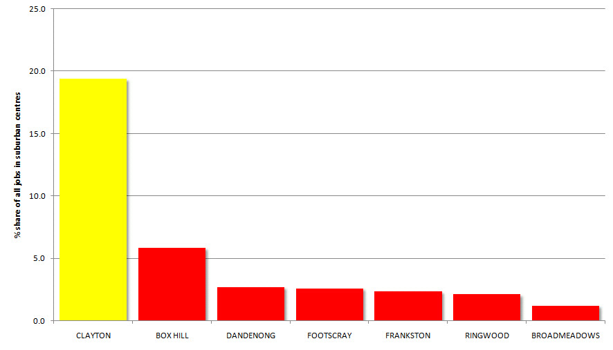
For Infrastructure Australia to start out with the assumption that "70% of Doncaster Rail's patronage would be cannibalised from existing public transport services" dooms that project's prospects before you've even got your calculator out, and it is completely fallacious when you look in detail at the evidence. Journey to work data shows that public transport mode share in areas proximate to heavy rail is SIGNIFICANTLY higher than this assumption presumes.

But for a party that currently holds two Victorian lower house seats to have put their plans for building a Metro 2  in the public domain whilst holding a straight face is just insulting to the voting public. Could one journalist not have insisted on their explaining how and in what parallel universe this is ever going to happen?

The Greensplan. Note also they are claiming credit for extensions to Wollert and Wyndham Vale,
both of which have been in PTV's Network Development Plan for YEARS ...


"If we held the balance of power in Victoria, committing to building this would be a key prerequisite for our support", would be a good answer to that question. Without that, we are left with - "well, we are going to quadruple our Statewide vote from current opinion poll data, and from our highest ever recorded level of support in just 3 months' from now, and thereby secure government".

But then you're also left with "and we're going to throw out any notion of deferring to Infrastructure Victoria and return to politicians using these billion dollar projects as political pork barrels." It's inspiring stuff, isn't it?

Transport Minister Jacinta Allan's response to the proposal was entirely the correct one. Even if the project stacks up, it absolutely cannot be built until the Metro One Project is complete. That is scheduled for 2021. 3 years from now.

You cannot undertake a project of this scale without fully three years of planning, systems and engineering prep work. That's exactly how long it has taken to get Metro 1's shovels in the ground after the election of the Andrews Government, so let's forget about implying sophistry on the Minister's behalf, and let's credit her with being the only party to the discussion who appears to be living in the real world.

You can add to that assessment the fact that there are actually a finite number of workers adequately skilled for these sorts of projects available at any given time, and if you try and build such a thing in an environment of scarcity, you wind up significantly driving up labour costs and ballooning the total cost of the project.

But there's another crucial reason why Metro 2 cannot possibly be built before Metro 1 is complete. We need to consider the interaction of the two projects and the overall project goals. In fact there may be a far more cost effective solution for Metro 2 which builds upon the infrastructure already in place for Metro Rail 1. Readers will be unsurprised at this point to learn there exists a patented Wombat Plan for Metro 2 which does precisely that.

Hang On, What IS Metro 2?

Broadly speaking, Melbourne Metro Rail 2 is the proposal to re-route heavy rail services from the western suburbs of Melbourne over the Yarra River from Newport Railway Station, thereby providing the new Fisherman's Bend development zone with much needed heavy rail access.

Most proposals to date have conceived this project as a rail tunnel running through Fisherman's Bend then back under the river to new underground platforms at Southern Cross Station, Flagstaff and CBD North, and continuing through the inner north before returning above ground at a junction with the existing South Morang and Hurstbridge lines.

However, we contend that there is a way of doing this which provides significantly better returns in the all important 'project benefits' column.

What's Wrong With These Proposals?

We start out with the proposition that the extra capacity potentially provided by this proposal at both Southern Cross and Flagstaff (the lowest trafficked city loop station by a significant quantum), is completely redundant to the network's needs.

We also contend that Melbourne has created a significant urban problem in the Southbank residential redevelopment zone. One of the main benefits of this type of living is supposed to be reducing car dependency, but we've seen a lot of data recently suggesting that car use and certainly car ownership in Southbank is actually out of control.

The area is walkable to everything in the CBD, and has trams running along Kingsway, Queensbridge and Sturt Streets, but these tram routes actually really border the main areas of the suburb rather than running right through it. If the logic exists to provide heavy rail access to the Fisherman's Bend redevelopment zone, the same logic should have applied when we were planning Southbank. We believe the heavy rail opportunity now created at Fisherman's Bend provides an opportunity to remedy the lack of planning at Southbank.

Melbourne Metro Rail - Wombat Style

We therefore propose that instead of running via Southern Cross Station, Metro 2 should continue east via 1-2 new stations at Southbank and re-join the remainder of the network at the Metro 1 tunnel, whose capacity it would share through the CBD, before running underground through the northern suburbs and meeting South Morang/Hurstbridge roughly as per existing proposals.

Click the images below to enlarge.


So, we're essentially creating 4 new stations south of the river - Wirraway (which I've situated so it can in fact serve both the Wirraway residential zone and the designated employment zone to its north), Sandridge, Casino/Convention Centre, and Southbank.


In the north, which is really pretty well transport enabled already, it's just two new stations for the shorter tunnel - we see the return from the dead of Museum Station (at which far too many people arrive by car - the location was never sensible from this perspective) and Johnson St, approximately half way between Smith and Brunswick Streets. Alternative name would be "The Rochy" :)


Metro Tunnel Capacity

The obvious benefit of the Wombat proposal over anything running via Southern Cross is the shared tunnel infrastructure with Metro Rail 1. Armchair critics will already be reaching for their revolvers about the limited capacity of that tunnel reintroducing a bottleneck into the network.

I fully concede that would be the greatest weakness here, but I don't think it actually need be a limiting factor once we sit down and actually look at the numbers, given that we are building the Metro 1 tunnel with future high capacity signalling in mind.

Let's look at how this might work. We are suggesting that ONLY Werribee line trains be re-routed through the Wombat Metro Tunnel, and that Williamstown line services would continue to run above ground to Southern Cross and/or Flinders Street, otherwise we're left without any trains at Seddon, Yarraville and Spotswood.

Looking at the 2016 Network Development Plan's projections for 2026 - 20 peak hour services are scheduled to run via Newport. Unfortunately the plan is agnostic as to how many of these originate from Williamstown and how many from Werribee, but let's assume a ratio of approx 3:1 in Werribee's favour, so let's say 14 and 6. It assumes 14 services running via the Metro 1 tunnel by the same date.

PTV Network Development Plan
Peak hour projections for 2031


So the key limiting question here is whether the capacity of the Metro Tunnel would allow for 28 peak hour services within the tunnel under construction. Given the current, prehistoric, steam powered network signalling has an acknowledged capacity of 20 trains per hour, we're looking for a 40% improvement, to allow a train every 2.18 minutes.

Network signal capacity is something of a dark art - as we're already experiencing with the high capacity trials underway, but there is no denying that this demand would be within the acknowledged international capabilities of high capacity signalling systems of up to 36 trains per hour.

At the other end, we then have the option of re-routing either the entire Hurstbridge or South Morang Lines through the tunnel (both would not be an option for capacity reasons and it would again render a whole raft of inner city stations redundant), OR this could be the route of a future Doncaster rail link along the Eastern Freeway.

Looking ahead to 2031, if the Airport rail link DOESN'T utilise Metro 1 tunnel, and instead runs direct to Southern Cross, then we would need to be able to run 33 trains an hour through the tunnel, and we concede that this would be straining the upper limits of today's high capacity signal technology, but you would then have the option of running some Werribee services above ground to Southern Cross to further mitigate.

PTV Network Development Plan
Peak hour projections for 2031


Furthermore, if the capacity constraints were only in a single direction through the CBD, you would actually have the option of running some Werribee services BACKWARDS through the CBD - ie above ground from Newport - South Kensington then into the Metro 1 tunnel and returning to Werribee via Fisherman's bend.

So there you have it. We tender the merits of the Wombat Plan on the basis that it
1. Minimises costs through shared infrastructure
2. Provides heavy rail access to major destinations and public transport blackspots in Southbank
3. Creates future capacity for Doncaster Rail (the peak hour constraints would all be in the opposite direction)

Would love to hear your thoughts, opinions or feedback below.

Tuesday, 5 January 2016

High-Speed Rail is a Dumb Idea for Australia - but a brilliant one for Victoria

The (Shaky) Case for HSR in Australia


The 2013 High Speed Rail in Australia Study Phase 2 Report (large pdf file) was delivered in 2012 as a preliminary study towards constructing High-Speed Inter-Capital Rail along the Australia's eastern seabord.

The study proposed a service allowing for conventional High Speed Rail express journeys from Sydney to Melbourne taking 2 hours and 44 minutes. The cost of the proposed project was
"about $114 billion (in 2012 terms), comprising $64 billion between Brisbane and Sydney and $50 billion between Sydney, Canberra and Melbourne." 
The study predicted
"By 2065, HSR could attract 40 per cent of inter- city air travel on the east coast and 60 per cent of regional air travel (primarily long regional). On the three main sectors, Sydney-Melbourne, Sydney-Brisbane and Sydney-Canberra, HSR could attract more than 50 per cent of the air travel market." 
The current flight time from Sydney to Melbourne is 1 hour and 35 minutes. So allowing for the extra transfer time required with air ravel, where one generally arrives an hour before one's flight after traveling half an hour or so on a freeway, HSR would APPEAR to be relatively time competitive to its alternative mode.

But consider this - Sydney's current airport rail link carries just 17% of traffic to the airport. The alternative mode via taxi or private vehicle is both cost and time UNCOMPETITIVE with rail transit. Travelers know they'll still need to factor in getting to their hotel or wherever once at their ultimate destination and lugging their bags via some means to the train station. Somehow rail always seems sexier as an idea than as a reality to people.

The Phase Two Report numbers seem intuitively optimistic to me. I just can't see business travelers, who make up the majority of this route shifting to train travel, where the company gets their cab fare at either end anyway seeing the imperative to travel by rail. However they are backed up by international research into mode-share for HSR versus air over similar distances and volumes.

But the Phase Two Report makes it explicit; "A key (benefit) component is the assessment of time savings for travellers across their full journey including travel time, waiting time, check-in time and access time, with adjustments for the inconvenience of having to change modes."

The gains here all accrue to the private sector, but require a huge public subsidy to facilitate them. That should be an enormous warning sign to any elected official that their project is about transferring value FROM the public purse.

And that private benefit will accrue on, again by the report's own numbers, just 18,760 Melbourne-Sydney trips a year. For a $50bn pricetag. 
Over a decade, that's a 0.26 million dollar public subsidy PER TRIP. This is just ludicrous public economics. 
Let's be clear - our biggest policy problem in Australia worthy of $50bn of public funds is NOT the higher emissions caused by people traveling from Melbourne to Sydney by air.

Nor is it the amount of time these people spend getting to or from the airport a handful of times a year on average. Air transport emissions are an issue of certain public concern obviously, but in the greater pantheon of public spending demands, it isn't remotely on the radar.

But the straining of our eastern capital cities IS. Enabling regional commuter centers and allowing us to end the process of urban sprawl that leaves the city's most needy consigned to urban ghettoes with poor social services and networks IS, at least for this commentator somewhere close to the top of our list of needs.

INTER-CAPITAL HSR

- BUILDING THE WRONG NETWORK 

And so it gets worse.

Again the Phase Two Report states "To achieve the target journey time of under three hours for Sydney-Melbourne, an average journey speed of approximately 300 kilometres per hour would need to be achieved. This would require a system capable of a maximum operating speed of 350 kilometres per hour, to allow for some slower sections of track."

But the study also clearly articulates that these speeds won't be possible if the network is also used for commuter travel into suburban centres. IE this whole things assumes the trains are EXPRESS Melbourne to Sydney which COMPLETELY DENUDES HSR OF ONE OF ITS KEY BENEFITS - FACILITATING THE GROWTH OF SATELLITE COMMUTER TOWNS.

If the speed of the network is reduced to 250km/h then the Sydney-Melbourne journey time balloons to three hours and seventeen minutes - and over four hours at 200 kph.

So, we can't have a network that does both - intercapital and commuter HSR. And because I see all the REAL PUBLIC benefits from HSR as accruing from a commuter network, I believe every sane advocate of HSR in this country needs to be clamouring for an immediate re-assessment of the project's priorities to create a COMMUTER network as first priority, one that could be expanded into an inter-capital network at a later date.

COMMUTER HSR FOR VICTORIA 

- BUILDING THE RIGHT NETWORK 

Towards that end, this week we're looking at what an effective HSR network enabling commuter travel into MELBOURNE might look like, and what benefits would accrue to the state of Victoria from such a network.

Proposed Victorian High-Speed Rail Network in Stages

OBJECTIVE
To best enable commuter HSR to maximise the number of commuter journeys possible into Melbourne from effective satellite regional centres.

COSTING
This proposal is costed on the basis of the Phase 2 Study estimate of construction costs of $56m per kilometer on its proposed Shepparton-Melbourne section. This incorporates a higher cost of getting HSR in to Melbourne, but under my model if we use the existing RRL tracks/reservation the cost per kilometre may be signifcantly lower. It should also be noted that the Phase 2 Study costed track graded to run trains capable of 350 km/h. My figures only anticipate running commuter services at the lower speeds of 250 km/h, requiring track capable of max 300 km/h. So, my actual figures should be either be CHEAPER than those shown if a lower capacity track were used, or my time savings HIGHER than those indicated if we had higher capacity track.

The total construction cost of the proposal at face value is $17.03 bn. Allowing for some featherbedding, we can comfortably state the project could be delivered for under $20 bn.

FUNDING
Instead of spending $50bn on Melbourne-Sydney HSR, Canberra should jointly fund this $20bn project with the State of Victoria. It would therefore represent a $10bn investment towards the long-run development of Melbourne-Sydney HSR. Victoria would then need to find $10bn, which could easily be done with a combination of value capture methods, debt, or even a one-off "Melbourne congestion levee" implemented probably best via a Melbourne Water surcharge on everyone in Melbourne, Ballarat and Bendigo who all stand to gain from the proposal.

ROUTES/STAGING
In line with the above objectives, our best potential established regional commuter centres - by distance to Melbourne - are Ballarat, Geelong and Bendigo. At present PTV's plans for Geelong involve a long-run electrification of the route, without any clear timeline. No upgrades are planned for the Ballarat or Bendigo routes.

I propose instead, because all these services now run on dedicated Regional Rail Link tracks through suburban Melbourne, that the Ballarat and Geelong routes be completely replaced by HSR in to Southern Cross Station.

Instead of replacing the Bendigo line, which currently runs direct from Castlemaine-Melbourne and only uses Regional Rail Link from Nth Melbourne Station to Southern Cross, it is proposed to create a new HSR Bendigo-Ballarat route replacing the existing track section Bendigo through Castlemaine and with a new dedicated HSR track running via one of two routes to Ballarat, depending on whether Daylesford is included in the network.

ISSUES
Under this proposal, I envisage V/Line services continuing with existing V/Locity rolling stock on the existing Bendigo line as far as Malmsbury - that being the northernmost station that wouldn't receive HSR, although it may only be economic to continue it as far north as Kyneton. Under this proposal, this line would to return to sharing the network with Metro trains between North Melbourne and Southern Cross, though this would be a relatively minor issue.

A bigger issue would be how to have Metro trains service the planned future Melton line electrification if the RRL tracks were ripped up for HSR. One I'll set aside because it's kind of boring, but it's one that would need to be solved for Tarneit and Wyndham Vale Stations also.

The only major question posed by route selection is whether the increase in travel time to and from Castlemaine and Bendigo that would result from including a Daylesford stop on the route would be justified. At the estimated increase in time of just nine minutes, this would seem justified based on the potential to Victoria's tourism industry of being able to take a one hour train trip to Daylesford.

As stated, both the Ballarat and Geelong lines would be replaced in their entirety using current alignments and easements, with the sole exception being the dog-leg placed in the Melbourne-Geelong route to allow for the inclusion of Avalon Airport.

Provision of heavy rail to Avalon remains a major public policy concern in Victoria, and the deviation would add a matter of around three minutes to the journey, so this is a negative-brainer.

Another issue will be the need for planning and provision of metro-style public transport infrastructure in regional centers. In fact the current Victorian government has commenced tentative planning towards this end in some centers. It would need to be coordinated and consider how metro services in Geelong in particular would interact with the HSR, where HSR tracks in Geelong would replace notionally "metro" ones in the north of the city. A large part of the featherbedding in my costing is to allow for necessary track duplication works (possible with double-decking) into urban areas.

STAGE ONE - Ballarat to Southern Cross

High-Speed rail for Victoria -
Stages One (purple) and Two (blue)

Stops
Ballan
Bacchus Marsh
Melton*
Rockbank*
*to be serviced by Metro in future

Distance
121.8km 

Projected Cost
$6.8bn 

Time Savings
Please note these times are based on existing train travel times, although for our purposes a better comparison might be with current motor vehicle transit times, these are almost impossible to extrapolate meaningfully into the future.

Because Stage Three of the project envisages Bendigo trains running express from Ballarat to Melbourne, passengers will at that point be offered an even speedier express service to Melbourne.

It is envisaged that as per present services, demand to Melton and Rockbank would not initially warrant all services stopping there. Accordingly, Ballarat-Melbourne travelers would have a choice of "two stop" or "four stop" services, and ultimately also an express service.

Ballarat - Melbourne with four stops via HSR travel time 48 minutes down from 72. Save 24 minutes.
Ballarat - Melbourne with two stops via HSR travel time 42 minutes. Save 30 minutes.
Ballarat - Melbourne HSR Express travel time 36 minutes. Save 36 minutes. Travel time HALVED.

If that sort of quantum change isn't enough to induce the kind of responses we are looking for with this policy, well I'm keen to hear of any policy that could possibly do MORE...

Please note also that these time savings are predicated on speeds of ONLY 200 km/h. The likelihood of being able to build a network attaining speeds of up to 250 km/h without much incremental expense is extremely high. So these estimates are at the PESSIMISTIC end of the spectrum. The reality SHOULD be even better.

Proposed Victorian High-Speed Rail - Urban Section

STAGE TWO - Geelong to Deer Park

Stops
Lara
Little River
Avalon Airport
Ardeer*
Deer Park*
Tarneit*
Wyndham Vale*
*to be serviced by Metro in future

Distance
61.3 km new track

Projected Cost
$4.5bn 

Time Savings
As per Stage One, not all these stations demand being serviced by every train. It is envisaged travelers from Geelong would have the option of an "Express" service to Melbourne stopping only at Avalon Airport, in addition to the slightly longer services.

Geelong - Melbourne with six stops travel time 42 minutes, down from 62. Save 20 minutes
Geelong - Melbourne with four stops travel time 36 minutes, down from 62. Save 26 minutes
Geelong - Melbourne with one stop travel time 27 minutes, down from 62. Save 35 minutes. Travel Time more than HALVED.

STAGE THREE - Bendigo to Ballarat

High Speed Rail Stage Three (red), showing alternative ex. Daylesford route (light blue)
and proposed national HSR alignment (dark blue)

Stops
Kangaroo Flat
Castlemaine
Daylesford?
Ballarat
Service would run express Ballarat-Melbourne

Distance
123.5 km  via Daylesford

Projected Cost
$6.9bn 

Time Savings
Bendigo - Melbourne via Daylesford with four stops travel time 86 minutes down from 112,
save 26 minutes.
Bendigo - Melbourne ex Daylesford with three stops travel time 77 minutes down from 112,
save 35 minutes.


Directing Victoria's and Melbourne's Growth

So, the proposal would then set us up with the following:

Designated Regional Commuter Centers 
Greater Ballarat, Greater Geelong, Greater Bendigo, Lara, Little River, Ballan, Bacchus Marsh and Castlemaine.
NB I wouldn't propose significant residential development for Daylesford, where preserving and enhancing Tourism and Heritage values should be the objective.

Urban Fringe Stations with Fast Rail Access
Ardeer, Deer Park, Melton, Rockbank, Tarneit, Wyndham Vale 

Looking beyond this though, while it will be these designated commuter cities that stand to benefit most economically and socially from fast rail access to Melbourne, travel times will be reduced significantly to a vast range of regional towns that would it is envisaged retain their existing V/Line service as a shuttle to the nearest major center.

So, we should actually see benefits accrue to Swan Hill and Echuca, Ararat, Maryborough, all of which would still be a relatively short hop to being on the High Speed Network, and even further flung places on the network like Colac and Warrnambool should benefit proportionately also.

Proposed Northern Victorian High-Speed Rail with V/Line Shuttles (yellow)
and proposed national HSR alignment (blue)

Proposed Southern Victorian High-Speed Rail with V/Line Shuttles (yellow)

What About Freight?

Ripping up the tracks to accomodate the HSR should be easy enough, but what about freight to places like Ballarat and all the towns they serve? I don't believe it has been attempted anywhere in the world, but there would be no reason not to run a high speed freight service along this route also as per demand, in fact there would be a lot of reasons for.

Doing so would be the prelude to one way a national HSR may someday happen. We've seen the cost-benefits don't stack up, but they MIGHT if we could incorporate inter-capital HSR freight as a means to removing a large amount of the truck traffic from our highways, resulting in lower maintenance, fewer accidents, air particulates, etc.

Not to mention we'd possess an absolute world beating eastern seabord freight network by way of national competitive advantage. Because doing this initially Sydney-Canberra ought to make sense on a similar basis to the above, and if we've gone as far as Bendigo, building the extra stretch in the middle might make sense down the track.

I dunno. To my eye, all of this seems to offer a lot more concrete than any of the nebulous and largely non-public benefits we've yet heard of associated with building a national HSR network. What do readers think?

Thursday, 29 October 2015

Greg Hunt's Melbourne 2200 Vision is an Expensive Flop - Here's How It SHOULD Be Done ... Part Four

PREVIOUS POSTS
Revisit Part One - Network Needs
Revisit Part Two - Expansion Phase One
Revisit Part Three - Expansion Phase Two

Road Improvements 
As stated, this entire plan is predicated on the assumption that road projects are inevitably going to deliver diminishing returns in terms of an ability to improve Melbourne's transport network capacity, and will not deliver anything transformational in terms of current usage patterns. That said, I have allowed for some very obvious projects to address all the remaining network issues presented by the existing roads network. Three of these four projects are situated around the geographic heart of the network.

Western Distributor
I've allowed, in order to show the full network effects, for the seemingly inevitable construction of the Western Distributor along the lines already put forward by Transurban. That this can be achieved at minimal cost to the public purse, and addresses some of the capacity issues on the West Gate. This is therefore a complete no-brainer.

It must be said, this is going to be an elevated road right through the middle of an area I've identified as Melbourne's prime urban renewal zone. Ideally this would be done with a long term structure plan for the redevelopment of the Port already in place. We don't live in an ideal world, but I hope readers can see that there are is a slew of long-run issues around which Melbourne only stands to benefit if it were to engage with them in a systematic, integrated and planned manner.

Instead this road will be built in the next five years, the can will be kicked down the track as to what the future of the Port is, and planning will continue to operated in an unprogrammatic, ad hoc and short-term manner.

That's ONE thing Greg Hunt promised to rescue us from. A willingness to embrace a bold vision in order to radically reconceive this city's transport usage patterns rather than just play patch-ups with existing demand is vital if we want to deliver an outcome that looks significantly different to the present day.

Proposed Western Distributor and Second River Crossing (green)
Second River Crossing
In order to provide a long-run solution for West Gate capacity issues, a second river crossing is going to be required. As per previous, I'm proposing a shared road and rail bridge, and similar to existing proposals would then tunnel the road component through to Geelong Road.

Remember, of course I am COMPLETELY relocating the Port of Melbourne. If there's any argument for retaining any port facilities at a central location (and I'm yet to hear a single practical such reason in the ten years I've been banging on about this), then that should be done at Webb Dock. So, this bridge doesn't need to be West Gate tall, it needs to be Bolte tall. Container ships won't be traversing the Yarra mouth anymore.

An Alternative East-West Link
There are two main issues with the termination of the Eastern Freeway in Abbotsford. The first is providing a link for traffic transiting to the northern suburbs, the second is providing a link for traffic accessing the CBD, aka the "Punt Road Problem". The East-West link only ever addressed the first of these two issues.

My proposed solution, as already flagged, is for a combined road and rail tunnel from the end of the Eastern freeway to access Footscray Road at Docklands. From there, traffic either heads north or South on CityLink or accesses the CBD,

This of course also provides effective access via City Link to the West Gate and Monash, and it obviates the need for a major upgrade of Punt Road, which instead can be planted with lovely green medians and bike lines and two lanes of traffic either way.

You'd also need to look at improving the City Access route from Footscray Rd, as this becomes an horrendous bottleneck at Docklands already.

All Proposed Central Roads Network Improvements

M80-Eastlink Connector
As previously flagged, I'm allowing the final wet dream of VicRoads freeway planners, completing the outer orbital road network by linking the Ring Road with Eastlink. I recently worked in Thomastown and this area of Melbourne is thoroughly dysfunctional in terms of its transport connections to any major urban centers. Getting anywhere in that part of the world in peak times is a wholesale nightmare. As we've seen, network development would only provide any kind of heavy rail solution to this region in a mooted stage four development.

Again, this would also ideally be a combined road and rail tunnel to allow for that development, but realistically getting that sort of expense costed into a road project would be a pipe dream for an extension even I can only characterise as "mooted" at this point.

Proposed M80-Eastlink Connector (green)
The Complete Plan
And, so there it all is. Networked solutions for both road and rail to allow for a metropolitan area that establishes significant CAD zones dispersed in such a way as to make the rhetoric of "twenty minute cities" a practical possibility.

What is the likelihood of any of this coming together in a comprehensive plan? Practically none. Ambition this lofty in political terms always ends up in flames. But I will say that my Outer Orbital line runs very conspicuously through a slew of Eastern suburbs marginal electorates. A party that went to the people with a policy to radically improve the amenity of  and indeed completely reconceive transportation in the suburbs would have a very solid platform for election. And we know this geographic zone is the precise place where Victorian elections are won and lost.

But of course this is all going to cost an absolute motza. I would propose all this in the context of a willingness on behalf of the State Government to commit the requisite resources to the plan as an wholistic thing. Cherry picking preferred projects from a plan like this also devoids it of the systemic benefits that are its entire rationale.

So, to do this, a government would need to go to the people with a plan to borrow tens of billions of dollars annually to deliver it. In a manner the Japanese and Europeans wouldn't lose a second's sleep in committing to. In a manner that the present government HAS recently flagged a willingness to countenance.

You might point to the public finance issues in both Japan and Europe, but I'd point to Germany and most of Europe being basically OK in deficit terms, and the PIGS in fact being such a tiny set of exceptions they actually disprove a link between SENSIBLE debt-funded government investment and the deterioration of a government's financial position over the long run.

We could talk about the possibilities for PPPs here. We could talk about the possibilities for developing air rights around stations or under viaducts if we sought to build as large a component of the network extensions above ground as possible. Ultimately, costing this stuff is largely a finger in the air exercise. But I've tried to show my working below.

Again, I return to possible double decking options for suburban arterial roads as one means of  reducing the cost of doing this. I intend to produce a future post that will do a case study on how and where this could work.

A Metro to support London-esque density?
Returning briefly to one of my original premises, we can see how my plan significantly retrofits rail to the inner Melbourne area in a way that should enable better medium density development across the inner Melbourne region. "London-esque" might be a little ambitious here, given Melbourne starts from a long way behind in that regard. But in essence I have moved from this, representing the present day,


... to THIS ...


... as compared with London today ...


We should not of course be looking at a plan like this in isolation from the tram and bus network. Indeed, we probably shouldn't be too scornful of the work the bus network actually does, easy as that is to do in Melbourne transport planning. It carried over 118 million journeys in 2011, which is the most recent available data, at 17% year on year growth. That's more than half the number of journeys taken by train in 2013-14, a percentage that frankly surprised me.

I do, however believe the suburban bus network is woefully inadequate in terms of the effectiveness of its integration with other areas of the network - and that most particularly is an issue around basic timetabling and frequency. Buses, as I have said already do have a VERY SIGNIFICANT role to play in increasing the effective catchment areas of suburban stations, and accordingly you COULD achieve a large part of the intentions of this plan through improvements to the suburban bus network at a fraction of the cost, but I would also argue at a fraction of the effectiveness.

In fact this plan actually directly envisages, given how many of the Western suburbs blackspots are left for a mooted "Stage Four", plugging most of those gaps over the medium term through provision of improvements to both the bus and tram/light rail network. As we're doing MAJOR urban renewal at the Port of Melbourne, running serious light rail around Footscray road at least as far as Footscray itself is basically inevitable.

The point should also be made that proper planning in the Western suburbs can and should have us avoiding entirely the creation of these more hypothetical blackspots. I live in hope.

But the final task here is to look at how this would all be staged and what this would all cost, and I don't intend to cost out and compare these various contingencies. These costings are all so notional that would be a misguided exercise. You're not getting an assessable set of cost-benefits out of four meagre blog posts, where you can do a lot of this notionally in your own head.

IMPLEMENTATION


Rail Improvements - Stage One

Upfield Extension
Depending on the level of duplication and track upgrades required here, it's only about two kilometers of track, so this is tens of millions at worst.

Alamein Extension
This is about 1.3kms of above ground, then 1.5 km tunnel to Chadstone, then double decking to Oakleigh. $2 bn


Glen Waverley Extension
As this is 15kms of tunnel, it's not going to come in much south of $10bn


New Branch Line via Monash  
This would invite a double-decking of Wellington rd to Rowville and a tunnel from there, but it's still about 10 kms of tunnel. $2bn to get to Rowville $8bn from there. This project could also be staged, with the section from Rowville to Ferntree Gully shifted to Rail Stage Two. 

Doncaster Rail via Newport
This is easily the most complex of the Stage One improvements, so probably invites a bit more of a breakdown:
  • The new Yarra bridge would be probably hundreds of millions
  • Cut and cover through Fishos could be done relatively cheaply assuming issues are resolved such as an available brownfields route would exist through the urban renewal zone. $20 million
  • Rail Tunnel to meet Metro rail $2bn
  • Road and rail Tunnel to Victoria Park/Freeway $6bn
  • Eleveated Rail most way to Doncaster $2bn
  • Tunnel to Doncaster 1.3 kms from the freeway $1bn
  • Doncaster to Ringwood rail Tunnel - one other double decking option would present itself here with the proposed tunnel route to Ringwood running parallel to the Eastern Freeway. But if this were a 10km tunnel, per the above, this would come in at around $8bn
So the ballpark for the total Doncaster rail improvements, including Fisherman's bend would be $20 bn.

The ballpark for stage one rail would be $42 bn.

Rail Improvements - Stage Two

Airport Line
Detailed costings were of course left out of the Bailleau government study, but based on the way the cost of Melburne Rail Link jumped when the airport was included, around $3bn is a pretty safe bet.

Outer Circle Stage One - Cheltenham to Templestowe
This stage would be prioritised as it addresses the majority of existing eastern sub urbs heavy rail blackspots. The northern section (stage two) does not traverse any blackspots. Without addressing any of the alternative technologies here, this is thirty kilometers of rail tunnel, and $100bn at a blush.

The ballpark for stage one rail would be $103 bn.

Rail Improvements - Stage Three

Outer Circle Stage Two - Templestowe to Airport
This is around 21kms of tunnel, so let's go with $80bn

Road Extensions

Western Distributor
Proposed at no cost to the taxpayer through Transurban.

Second River Crossing
As we've costed the bridge above, this is the cost of the tunnel to Geeong Rd and connections to the existing West Gate Freeway. $5bn for the tunnel, $6bn total. Tolls would be something I'd encourage here. In fact tolling the existing West Gate again as well. In fact tolling all the roads ...

Alternative East-West Link
Let's go with roughly the same cost as East-West link, but allow for the fact this only requires one tunnel. Not the complex messing around with City Link and linking it to the docks. So $15bn down to $10bn down to maybe $8bn allowing for synergies from building along with the rail tunnel for most of the route. Costs would be recouped by tolls (and I believe the cost-benefit for this WOULD be positive because you were solving the Punt Road problem too) and through PPP type arrangements.

M80-Eastlink Connector
Priority would be given to the inner-city road network improvements, as even by VicRoads' assessment, the need for the M80 Connector is still emergent rather than latent. So this would be a "Stage Two" road. Greg Hunt has costed this at $6 bn. It would be more like $10bn to include a rail tunnel within this.

The ballpark for all road improvements would be $26 bn. About the right proportion, methinks.

Unstaged Plans

Relocation of the Port of Melbourne
Along with associated rail yards and sale of the land for  urban renewal.
Uncosted - possibly revenue neutral

Creation of TWO new Ports at Geelong/Bay West AND Hastings
I'll also leave these uncosted, as this investment is to a large extent already planned and required because of looming capacity issues at the present site. So I'm building larger Ports elsewhere, and that WOULD significantly increase the expense of this project. But once again, what are the opportunity costs to the whole of Melbourne from NOT undertaking this investment, NOT getting significantly more freight on to rail, NOT having the ability to accomodate half a million people in a brand new suburb RIGHT NEXT to your existing CBD RIGHT on an existing train line?

I believe ALL these costs are not just significant, but major. I believe this proposal actually provides a therefore cost-effective solution to some of Melbourne's most significant and pressing urban development issues.

Conclusion

In upshot, I'm saying all this could be done for a mere $250bn. So, I'm putting a plate around, we should have this easily. Or rather, put a few bonds around. And if you believe in the arguments about what economic benefits transforming existing transport patterns can deliver, annualise the expense appropriately, I think a genuinely competitive cost-benefit would at least theoretically be capable of being produced around all of this.

But toss all this around in your own mind. Insert the costs of alternative methodologies, and I'd love to hear what you came up with by way of alternatives. What I'd really like all this to start is some genuinely blue-sky thinking in terms of what transport policy, coupled with very significant investment can do to give us a competitive advantage in the increasingly competitive global marketplace that urban centers increasingly find themselves competing within.

GO! Break it all wide open.

Yours,
The Wombat.

Saturday, 24 October 2015

Greg Hunt's Melbourne 2200 Vision is an Expensive Flop - Here's How It SHOULD Be Done ... Part Three

PREVIOUS POSTS
Revisit Part One - Network Needs
Revisit Part Two - Expansion Phase One
Visit Part Four - Roads and Costings

AIRPORT RAIL
My plan provides for TWO airport routes.

The first follows the recommendations of the Liberal government's working group. I agree that electrifying the existing Albion freight corridor is easily the cheapest and most effective solution. I do, however consider it madness, based on our earlier blackspots analysis to do this without adding any new stations to service the large blackspot the route runs right through.

So this first "Airport" route would cater for passengers transiting to and from the CBD, departing Southern Cross via the existing Sunbury line to Albion, and along the new corridor from there. I would propose a limited express service, stopping at North Melbourne, Footscray, Gladstone Park and Albion.


I'd strongly suggest the use of modified rolling stock that allowed for significant luggage storage areas on this dedicated service. I'd also strongly suggest a long-run needs assessment before making this investment, as demand is unlikely to be such that we'd need to be running six car sets. You'd want to keep a reasonable service frequency, and so smaller sets of rolling stock would probably be the most cost effective approach.

I have tried to apply some sort of notional cost-benefit approach to the solutions I'm putting forward, and I do think we need to be very clear that the working group study showed very clearly that this would not be a profitable enterprise until Tullamarine was generating a significantly higher number of passenger movements.

Thus, what I'm putting forward here in part three would probably form a "stage two" of network development. However, what I am about to propose by way of a second airport route is actually the network development project that would truly transform the nature of the rail network, and simultaneously work to activate a vastly expanded set of  CAD centers.

A METRO FOR ALL MELBURNIANS - THE OUTER CIRCLE
Much has been written and said about the way in which improvements in the transport network overall - and particularly Melbourne Metro Rail are set to accrue the majority of their benefits to the already relatively well-off, well networked, denizens of the inner city. This is somewhat silly, as the point of Metro  Rail is as much as anything removing the City Loop capacity constraint from the entire network, thereby actually enabling the entirety of the network extensions I've proposed to date.

Nonetheless, my plan does radically reconceive the transport possibilities for outer suburban residents through the creation of a new Outer Circle orbital route. This is where things get really expensive. We discussed in part two the possibilities of multi-modal technologies to deliver suburban rail extensions, and that approach should certainly be applied to planning for an Outer Circle.

But reality is, this, as you'll note from the map below, this is about retrofitting rail into established but poorly-catered areas, and the route traverses a number of green wedge zones. There's no getting around the fact that however you did it, you'll almost certainly be faced with a bill running to hundreds of billions of dollars by the end of the exercise, as the bulk of it is going to have to be underground. But if we believe that the benefits of radically revisioning this city's transportation patterns far better around nominated CADs are liable to be exponential, and I most certainly do believe that, you can justify an exponential level of expenditure if that's needed to enable it all.

The other point here is that if the benefits from this scale of investment are to be exponential, the opportunity costs of NOT proceeding need to be treated as real. If you believe not re-working Melbourne's transport is liable to impose an artificial constraint on the city's entire economy as commuting and related delays reduce productivity across the board, then once again this is something that SHOULD be included on your cost-benefit.

And finally, of course, if under Greg Hunt's scheme we're willing to spend hundreds of billions undergrounding existing routes to provide not one extra iota of utility to anyone, spending the same in a way that is actually calibrated to deliver real, tangible and transformative benefits most certainly deserves to stay on the table.


So, here it is. An orbital route running from Cheltenham in the South-East to connect ALL existing and proposed routes, excepting Alamein, Sandringham, Melton, Werribee and Williamstown. I'll discuss reasons for their exclusion shortly. Suffice to say I've allowed provision for further extensions so longer-run it need neglect only the more truncated Alamein and Williamstown routes.

The new track is orange in the image above. It is proposed the route would run TWO destinations from Cheltenham - one "Airport", the other "Albion". And it is trains from THIS, rather than the direct CBD-airport route which will service the newly created stations at Keilor, Gladstone Park and Gowanbrae. Passengers commuting to the CBD from these stations would be required to change at Albion.

Proposed Outer Circle - Northern Suburbs
Proposed Outer Circle - Eastern Suburbs
Proposed Outer Circle - South-Eastern Suburbs

You'll note a plethora of new stations along the route. These have been selected seeking to optimise the CAD effects around established mixed use zones with existing infrastructure. It is THIS project, which pushes the network most in the direction of our vaunted "four spokes" ideal of catering for radial travel into CADs.

MY PLAN - TWENTY SIX TOTAL SUBURBAN CADs
So, what then does this then give us in terms of newly-enabled CADs? The picture looks very much like this:

This covers five of the existing six CADs - Box Hill, Dandenong, Footscray, Ringwood, Frankston (not shown) and Broadmeadows (not included).

While there are certainly arguments to say Broadmeadows has plenty of natural factors that ought to recommend its inclusion within broader CAD policy, a transport solution giving effect to this would need to be part of any phase three development. As the plan stands, Broadmeadows' catchment is unable to be expanded through heavy rail solutions.

Furthermore, in spite of plenty of rhetoric to the contrary, the statistics we have seen show that the region is NOT actually a major employment hub at this time. The picture is similar in Frankston, although it has the advantage of still being the only major employment center south of Dandenong. Broadmeadows has considerably more direct competition, hence my dubiousness as to whether this is liable to occur in my lifetime.

Of my new proposed CADs, only Werribee isn't depicted. The reality is that Melbourne's east has matured and developed significantly more rapidly than its west, such that the logic is now essentially that the east is "full" and greenfields suburban developments will largely be confined to the city's west. And the whole idea of CADs is that these should be areas that have already accumulated a certain level of mixed use development, and should be employment centers and destinations in their own right.

Candidates fitting these criteria are largely absent from the west at present, although this plan obviously envisages provision to expand the network along the same principles as the west develops. Regardless of what happens, Werribee starts out with enough natural advantages as a CAD, that like Frankston, it's going to remain the most likely outer western candidate for the forseeable future.

So, the 21 new CADs, west to east are: Werribee, Sunshine, Pascoe Vale, Coburg, Preston, Richmond, Toorak, Burnley, Caulfield, Heidelberg, Camberwell, Chadstone, Oakleigh, Cheltenham, Clayton, Monash, Glen Waverley, Doncaster, Ringwood, Boronia and Ferntree Gully.

I've removed North Melbourne from the plan for now, because although it boasts an enormous catchment area with the confluence of so many lines, the station is busy mostly with transit passengers who never leave the concourse. The station surrounds are resolutely residential, and with high heritage values, so prospects for developing employment centers are limited. If e-Gate is pursued as a strongly mixed-use development, North Melbourne would readily find itself upgraded to a designated CAD. Richmond could be argued as a similar case, but has actually had talk of serious urban renewal efforts for a few years now, albeit with no real actual initiative, and the Cremorne light industrial area is set for significant transformation.

Toorak will remain in the mix regardless of any decision as to whether South Yarra will connect with Melbourne metro. This is of course an area that because of its many natural advantages is developing well as a mixed use, employment and particularly high density residential zone. So, absent of any changes to the station catchment, Toorak would be expected to continue to develop in this general direction.

Chadstone is the only nominated center that relies on a "two spoke" catchment, but is already so large and such a destination that it is agglomerating at a far more accelerated  pace than basically all the designated CADs. As we have seen, Monash and Clayton are also well ahead of the "vanguard" of designated CADs, and the provision of rail to both would be expected to significantly accelerate this process.

The remaining centers probably need little direct commentary, other than their having been selected for obvious junction points with established mixed use areas catered to by either three or four rail "spokes".

STAGE THREE AND BEYOND
Obviously, network development of this scale would take decades to complete even if we started tomorrow. But we know enough about the specifics of Melbourne's long term development to make some very certain predictions about its needs over that timeframe. And on that basis I tender this plan as far from the only one that would meet them. But I do think it is going to be essential, in order to keep this city functioning to give the fullest possible voice to advancing CADs policy with real urgency. And I do believe that the network development needs of the public transport system DO look VERY DIFFERENT if furthering CADs policy is given the primacy it deserves. On that basis I tender this solution as the optimal I've yet seen anyone propound.

I'll look quickly at what a proposed 'Stage Three development might look like, although the objectives here would be imagined to be accomodating the significant growth we'll by that time be seeing exclusively in the western suburbs.

Possible Stage Three Developments - light blue

Integrating Sandringham would be one final Eastern initiative, as well as on further branch line to plug the remaining outer eastern blackspot.

Then a second Outer Circle route to Ringwood would further cater to growth in the city's north. We will see in part four, which looks at the roads network, that my plan would allow for the construction of a road tunnel between Eastlink and the Ring Road. The final fantasy of VicRoads freeway engineers I intend to ever allow this city. By their own arguments that's it, once they've got a complete outer orbital ring road and East West Link, they are out of ideas. But we will see next time, ALL my suggested roads improvements are calibrated to ALSO interface with the public transport network, delivering SIGNIFANCTLY better bang for infrastructure buck.

Accordingly, this "second outer circle" would "borrow" the same road tunnel we intend to build for the section between Ringwood and Watsonia or thereabouts.

Finally, the obvious thing to do out West would be extending the RRL route to the airport, and the new airport line through to the Werribee line in order to both cater for growth, and maximise the number of metro-style linkages across the network.

So, taking stock here, we've now moved from THIS, the current network with significant blackspots


To this. A fully integrated metro system that addresses those blackpots directly. "Leave no Melburnian Behind", should be the catchcry, where transport access is concerned. Because it's actually a MAJOR social justice issue. This is about who gets to participate in and integrate with a huge, modern, networked economy, and who gets left behind permanently.


In part four, which I'll have ready in a mere couple of days LINK HERE ONCE LIVE, we'll look at how all this looks integrated with the roads network. Bring a cut lunch and a spare pair of socks. the ones you're wearing will be going into orbit.

PREVIOUS POSTS
Revisit Part One - Network Needs
Revisit Part Two - Expansion Phase One
Visit Part Four - Roads and Costings

Wednesday, 21 October 2015

Greg Hunt's Melbourne 2200 Vision is an Expensive Flop - Here's How It SHOULD Be Done ... Part Two

PREVIOUS POSTS
Revisit Part One - Network Needs
Visit Part Three - Expansion Phase Two 
Visit Part Four - Roads and Costings

A REAL MELBOURNE METRO SYSTEM
Among the acknowledged benefits of a rapid, regular metro-style rail service is the economic agglomeration effect generated around station sites, and this combined with a similar impact on housing density and increasingly house prices is a powerful set of benefits.

Let's have a look at London and Melbourne, viewed from an almost identical vantage. London is overlaid with its tube map as well as underground and overground rail stations, Melbourne with its current railway network and stations.

Inner London, with Underground Lines and Overground Stations
Inner Melbourne with Railway Lines and Stations

A few obvious conclusions are that the London network is more extensive (remember, overground lines aren't shown, only stations). The London network also services significantly more stations than the Melbourne network within any given area, including central/downtown/CBD. Any fool ought to be able to look at these two maps and indicate which is the significantly denser city.  The other obvious contrast is the predominantly radial nature of the Melbourne network against London's more distributed model.

Characteristics of a Metro system which might therefore be seen as lacking in contemporary Melbourne include:
  • More stations in inner city areas, enabling a more devolved, decentralised, larger CAD core with less focus on absolute height in the historic CBD
  • Greater connectivity between lines
  • A significantly less radial system, more "networked" in nature
  • A more even dispersal of stations, particularly across inner urban areas.
Metro-style rail can therefore seemingly be used, if London is any guide, to enhance the economic agglomeration effects within suburbs and to plan for increased density. There is however urgent the need might seem, scant evidence that policy in Melbourne is currently being used at all effectively towards that end.

CENTRAL ACTIVITIES DISTRICTS (CADs)
The history of planning for Melbourne's suburban CADs is one of a tremendous idea being launched and re-launched about five distinct and separate times. None of them involving any kind of substantive policy or follow-up whatsoever.

Furthermore, as Alan Davies has pointed out, there appears to have been little detailed work done in the nomination and selection of the six designated centres. "It seems the Government simply picked six centres under the existing Transit Cities Program and designated them as CADs." These are Broadmeadows, Box Hill, Dandenong, Footscray, Frankston and Ringwood.

I strongly believe the focus on a mere six or so suburban CADs is woefully inadequate to drive the revolutionary changes I outlined in part one. If you want to talk about "five minute cities" (and I really don't, given that's all so much conceptual hot air), then from a purely geographic perspective alone, you're going to need a lot more than six CADs to make this a possible time saving or mode shift incentive for enough people to make a significant impact.

My plan is based on the theory that institutions have a realistically finite geographic 'catchment' of shoppers, attendees, whatevers. And that catchment's size and shape will be determined by their transport options to the venue in question. It is based on the theory that the RADIAL TO THE CBD nature of our rail network is therefore working largely against the development of CADs, which in theory have their own potential radial catchment that is only partially catered for by the current rail network, which in a lot of cases purely bisects the CAD's catchment like two opposite spokes on a wheel.

My plan creates a series of twenty three suburban CADs, and a network development plan that services all of them radially via three or four railway "spokes".

My plan would support these changes with new planning zones around CAD stations to allow and mandate  higher density and mixed use. Councils would be actively discouraged from approving sizeable non-residental developments outside of these zones, and the State Government would develop incentives for businesses to relocate or establish there.

A key goal here is rationalising the number of routine daily destination points for Melburnians, and thereby enabling the ease with which the fixed transport network can service them.

AN INTEGRATED NETWORK
Another objective I am simultaneously trying to meet is delivering a system which acts more as an integrated web of stations, between which one can travel ultimately web-like in any number of directions without the need to travel in to a central point first, and a web which networks to all the major regular destinations - shopping and employment centres.

This is envisaged as applying to the bus network too. This invites arterial analogies, where the bus network is the fine capillaries that carries the oxygen that final few yards "home" and to either to the arterial rail system or a specific organ/CAD. So EVERY suburban bus that networks with the train system knows which train it connects with and it has no journey start time until it's loaded all the passengers from that train.

I see much smaller, cab-style buses taking smaller loads on numerous new radial routes to and from railway stations, but I'll discuss the other necessary enabling aspects of the network in part three.

BLACKSPOTS IN THE CURRENT NETWORK
Again using catchments theory, it's not difficult to identify where the key rail "dead spots" are in Melbourne. The following image uses Google Earth to highlight them in white, according to both existing and predicted future urban growth boundaries. That is to say, I've allowed for geographic growth in the west, but used existing residential areas in the east. Presently committed network extensions are shown in pink.

The obvious takeaway here is that the biggest gaps are at the suburban fringes sitting in islands between the existing lines. As the lines extend further from the CBD, the greater these distances become. The two furthermost right-hand zones give you an estimate of exactly how many Melburnians were sold out by the decision to terminate the Glen Waverley train line there.


A PROPER MELBOURNE METRO - NETWORK EXTENSIONS
There are currently three Melbourne train lines which terminate in the suburbs - Alamein, Glen Waverley and Upfield. When it comes to consider network extensions, these are the obvious places to start. This whole idea being enabled by the transformative elements of the Hunt vision, these extensions are predicated on a willingness to consider the cost of tunnel-based extensions to the network, thereby allowing complete flexibility in route selection.

In reality, these extensions could equally be enabled my a mixture of modes. I very strongly believe that there would be little resistance to for instance double-decking major suburban arterial roads like Springvale Rd with a train line, so possibilities exist for a number of these extensions to be performed through mixed tunnel and elevated carriageway. Cases could also be made for doing these extensions via light rather than heavy rail.

What I don't want this exercise to get bogged down in is route selection minutiae. Have a look at the feasibility study for airport rail if you want to get a sense of what a rabbit hole that sort of approach is, the entire discipline is beset with engineering complexities I'm in no way equipped to address. I'm headline policy, someone else would be implementation.

1. UPFIELD EXTENSION
The exception to the above is the Upfield line, where freight lines already exist to re-connect with Craigieburn just before Roxburgh Park Station. This extension is shown in red below. Existing lines are blue. It would be difficult to make a case for any new stations on such a short section of track through a heavy industrial area. Public transport into industrial zones is notoriously difficult because of the widely distributed proliferation of possible destinations. These areas don't have "CAD" areas where a station might otherwise logically go.

This would be the cheapest of all the mooted extensions given it's just an electrification of existing track. This extension does already exist within PTV's long-run network development plan. But we'll look at costings in further detail in part three shortly.

Upfield Line - Proposed Extension
2. ALAMEIN EXTENSION 
Most likely this would be the second-least costly of the proposed extensions. A wide bike path and reserve presently runs from the end of the Alamein line down to the river. This section could therefore be delivered overground, but the line would certainly need to pass beneath the  river and Monash Freeway.

The main purpose of this extension is providing a heavy rail solution to Chadstone Shopping Center. This access could be provided cheaper again via some double-decking of the Princess Highway and Warragul Road to Oaklegh.

This extension would provide interchange points at East Malvern for the Glen Waverley line, and Oakleigh on the Dandenong line.

Alamein Line - Proposed Extension
3. GLEN WAVERLEY EXTENSION
Now, things start getting really fun. As we saw above, the decision to terminate the line at Glen Waverley was arguably the worst planning decision in Melbourne's entire civic history. We now have a chance to envisage the network had this mistake never been made.

This extension runs from Glen Waverley to Boronia station on the Belgrave line. It includes a new station at Knox City. You'll note I've been pretty conservative with new stations on the extensions. I've largely used the criteria that new stations should only be created to a) allow rail access to a major, previously unserviced destination or b) allow rail access to a sizeable residential catchment not presently serviced by rail. You could certainly make a case for another one or two stations along an extensions this length, but the large "green reservation" alongside Eastlink means there's actually a huge residential vacuum that obviously doesn't need to be catered for running right through the middle of the extension area, which obviously would complicate the siting of stations.

Glen Waverley Line - Proposed Extension
4. NEW BRANCH LINE via MONASH
I also propose the  creation of a new branch line to run from Huntingdale Station via Monash University through Rowville to also reconnect with the Belgrave line at Ferntree Gully. This has been selected on the basis that Monash University probably sits somewhere near the top of the network's highest demand, presently-unserviced destinations, and as we've seen, this would traverse one of the network's largest overall 'blackspots'.

It's important to state here that the terminal stations with these last two extensions have been selected with a view to the terminal stations becoming newly designated CADs. The effect of these extensions is to add a third "spoke" to the station's effective catchment area, as previously stated with the purpose of allowing more radial travel to the CAD from within its catchment, such as would be impossible under the current "radial from the CBD model.

I  propose the creation of five new stations along this new branch line, so effectively there would now be fifteen, rather than ten railway stations within a five station radius of Ferntree Gully.

It's also important to state that one of the few areas we've had success in creating urban agglomeration of employment in particular around CAD-type centers have been the research and health precincts around Melbourne and Monash Universities. This chart, courtesy of Alan Davies tells the story more eloquently than I could. It shows what percentage of suburban jobs are in the existing six designated activity centres, relative to the non-designated Monash/Clayton.

This tells you EXACTLY how much planning and foresight has gone into initiatives around CADs to date.


While the new extension only creates two "spokes" leading to Monash, this would also be expected to be developed under my plan, as a formally designated CAD. The significantly larger catchment to the area enabled by this extension is crucial to that.

Monash Branch Line - Proposed
5. RAIL via NEWPORT and FISHOS
Moving back to the network's center, the other medium-run identified network need in terms of currently-unserviced destinations is the new Fisherman's Bend urban renewal zone. I am not the first person to propose doing this, but I believe I am the first to map any proposed extension back to long-run network needs.

Under my proposal, Werribee line trains would be removed from the City Loop, running instead via Newport station, over the Yarra mouth via a new bridge. As we later see when we look at road network extensions, this would actually serve both road and rail, providing the much-needed second river crossing, and freeing up capacity on the West Gate.

The new route would travel above ground via Webb Dock - it's important here to state that if any case is made for retaining any dock functions in the central city, that those activities should be concentrated at Webb Dock, and per part one of my proposal, and the remainder of the dock land be rezoned for medium density infill housing. This based on the idea that we have failed dismally to get more freight out of the ports via rail. This can only be remedied by the re-imaging of the entire dock rail infrastructure, such as the effectively greenfields site at Webb Dock would allow.

The route could then be cut and covered through the urban renewal zone, dipping into a new bored tunnel at Southbank to meet the Melbourne Metro tunnel somewhere south of the Yarra.

This route proposes two new stations in the urban renewal zone - Wirraway and Sandridge, and an underground station at Clarendon Street/Southbank, servicing the western end of the casino and the Convention Centre. There may well be issues with placing a tunnel in the Coode Island silt here. It's possible a Southbank station would need to be located further from the river, in which case you'd probably look more at something closer to South Wharf. Again, I don't want to get bogged down in too much of this sort of detail.

Fisherman's Bend Rail Extension - Proposed

6. NEW BRANCH LINE via DONCASTER
Most effective Metro style networks operate "cross-city" routes. Putting Werribee line trains in the Metro tunnel is not a solution in itself, as they'd then be forced to run on some weird loop back to one of the northwest group lines. This would not be catering to any identified major travel need.

When we look at airport rail in the next part, one other option here would be to run a Werribee-Airport route, if we decided Doncaster rail was not a priority at this time.

Proposed Doncaster Branch Line - Western Section
I propose the creation of two new stations at Lygon and Brunswick Streets in a new underground tunnel which connects Melbourne Metro to the Clifton Hill group lines just south of Victoria Park station.

This element of the proposal is CRUCIAL to the objective of creating an inner-city metro-style network such as London possesses whereby travel is dispersed across a wide range of inner city stations, and with that having been essential to London's significantly less CBD-oriented network. The effect of London's network has been to promote high-medium density development across a highly-dispersed set of inner city stations, most of which serve multiple lines.

I then propose to run a line along the Eastern Freeway reservation. A lot of work would need to be done on the new "freeway stations". Alan Davies has suggested the existence of significant open space reservations around the freeways will ensure the catchments for these stations are complicated. 

If you drew a radius around each of these stations, the area covered would include large unpopulated sections. These stations would not be integrated with other than the existing rail (or in fact freeway also) network. They would almost certainly function primarily as park and ride destinations, although significant thought should be given to integrated changes on the suburban bus network to create more effective public transport catchments for these new stations.

The stations would be significant undertakings, requiring extensive car parking and bus interchange points factored into the design.

Proposed Doncaster Branch Line - Kew Section
Proposed Doncaster Branch Line - Doncaster Section
I  propose to have this line leave the freeway via tunnel to Doncaster, and again possibly through a mixed mode of undergrounding and double decking to join the Ringwood group of lines directly AT Ringwood station (Eastlands). Ringwood would be another rare example of a designated CAD where some initial agglomeration does already appear to be occurring, and per previous examples, my plan provides a third spoke to increase the station's "five stops" catchment to fifteen rather than ten stations.

Proposed Doncaster Branch Line - Eastern Section
IN SUMMARY
So. We've come a very long way in the last thousand words or so.

We've moved from this, the present network with Metro rail, a swiss cheese of heavy rail blackspots...


... to this, the beginnings of a fully integrated, Metro style network ...


We've plugged a lot of those major blackspots out east, but there are still enormous network needs in the north and west. Arguably the boldest part of my plan moves to plug those in a way that will really highlight the transformative, revolutionary potential for urban development that getting the heavy rail network fully optimised and fully integrated will deliver.

I'll be back in a few days time to take the wraps off part three, whence the magic will truly have its genesis.

- The Wombat.

PREVIOUS POSTS
Revisit Part One - Network Needs
Visit Part Three - Expansion Phase Two 
Visit Part Four - Roads and Costings